The Commonwealth of Wellon
Regions of Wellon A Meeting of Minds The foyer of the Masira's Sultan Qaboos I Conference Centre was frigid with the blast of the air conditioning. The floor thronged with trade delegates circulating around the floor, furiously networking and pitching in the aftermath of the morning's lectures and presentations. It stood in stark contrast to the battering heat currently melting the tarmac on the road in front of the double doors. Two parties of near identically suited business people faced each other warily from either side of the room. 'Now remember Phil these ladies and gentlemen are from Point Sterling, they have their own ways of doing business down there that are not ours. They will expect us to stay up all night drinking with them, they'll expect us to take them to brothels, they ultimately expect us to bribe them with kickbacks. Trust me, I've seen it all before, I used to work down there. Don't trust them for an instant but don't fear them either, even though they are all probably related to triad members or are brothers themselves.' 'Oh no, not another bunch of humourless, Reformist, Dart-Moron bigots. Okay Al, you're the 49 as usual, remember the handshake. Chen, you are the lush, and I'm the drunk. Right, lets have some fun.' 'Mr MacDonald? A pleasure to meet
you!'
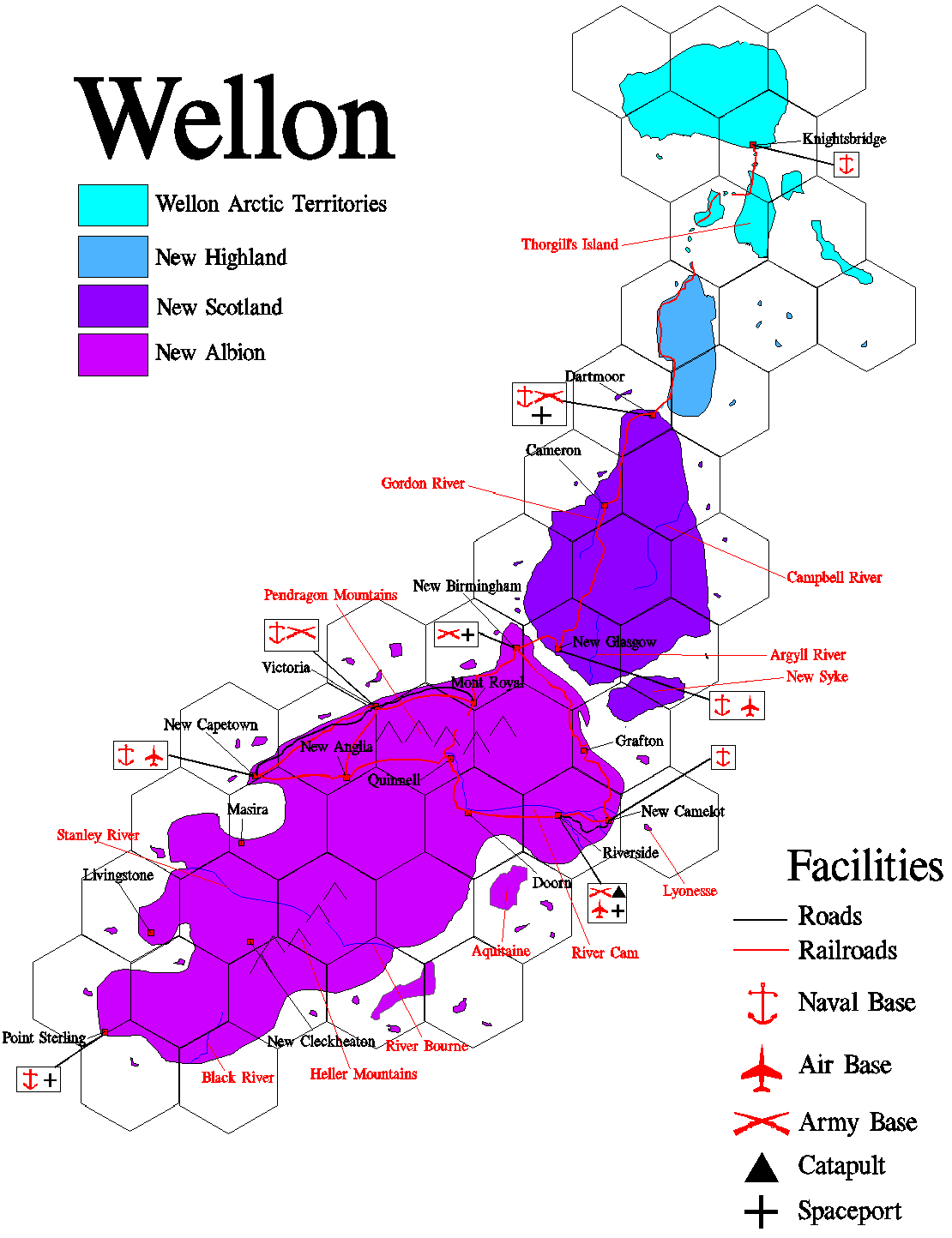
Wellon is currently divided into five administrative regions, each of which has an elected Assembly. These are Eastern New Albion, Western New Albion, Southern New Albion, New Scotland and the Wellon Arctic Territories. There are also some small parts of Tirane still under the direct control of the British. Below: Regional map of Wellon (click to enlarge)
Eastern New Albion is the core of the region that was once known as South Albion. It is dominated by the Cam River that runs for nearly 3000 kilometres through the centre of the region, and provided much of the basis for the area's economic development. The region stretches up to where Uther's Escarpment meets the Albion Straits just north of the southern mouth of the straits. The border then runs down the break line of the Pendragon Mountains. It then skirts the outer edge of the vast, fertile Dannon Basin before running down into the Blight. The border then becomes somewhat academic, cutting East to the sea along the 75th Parallel. The Cam River provides the lifeline of the area, with natural resources moving downstream becoming finished products for internal consumption or export from Riverside. Due to the size of the Cam Delta the river is navigable up to that city by sea-going vessels, although in places shifting sandbanks and channels pose a serious problem to navigation. The banks of the Cam have been used since the early years of the colony to provide foodstuffs. However the sometimes contrary nature of the Cam has led to the flood plains being given over to raising animals and local plants that require the flooding as part of their natural cycles. The cultivated areas have increasingly stretched back from the river bank into the interior with each extra wave of colonists. The Cam Valley is characterised by its patchwork of small farming communities that dominate the land between the major towns and cities. The original colonisation of the Cam Valley outside of the cities was undertaken primarily by planting communities consisting of family groups. These groups normally travelled together to Tirane, and were generally drawn from the same geographical locations at home. This model was generally successful, in that banditry was never a serious problem in the Valley, and the communities were originally self-sufficient. However in recent years agriculture in the region has become increasingly less efficient in the face of more competitive mass farming especially around New Anglia and in the central parts of New Scotland. Whilst some communities have managed to diversify, many farms have gone broke and many families have moved to the cities. North of the River Cam is a vast region of low, wet, forested hills and lakes known as the Marches. This rugged terrain is sparsely populated and most notable for the timber that is produced from the area, under close government control, as the region is a protected area. The few people who live in the area are as tough as the countryside, and have little time for the city folk or farmers of the Cam Valley. Mineral prospecting has increasingly taken place in this area. The Western Marches region is dominated by New Sherwood Forest. A dark and in places impenetrable woodland that rises up through the foothills of the Pendragon Mountains. The headwaters of the Cam are in the region beyond the city of Quinnell. This is a region of low, rolling hills and moors that rise steadily up into the Pendragon's. The area is sustained economically by mining and hill farming. The recent project to build a rail-link through the Pendragons to Mont Royal further north has given the region an unmistakable economic boost. The spectacular town of Richmond is mentioned in many tourist guides and is increasingly a major tourist destination. Perched high above the Swale tributary of the Cam on Luttrell's Ridge, the classical King Olaf's Hall looms over the town like some medieval fastness. The huge Moir & Son Corporation mining complex (dubbed 'Moria' by critics of the company's health and safety record) delves deep in to the central Pendragons and is within 20km of Richmond. To the south of the city of Riverside is an vast area of scrubby, infertile land that almost since the start of the colony has been used as a military training area. It is known as the Eastern Training Area, and generally it is an un-welcoming place. Generations of British, Wellonese and other soldiers have slogged along its length and breadth cursing its very existence. The southern and western parts of East New Albion south of the Cam are predominantly areas of grasslands and savannah that becomes dryer and more arid until it becomes the desert of the Blight. This area is known generally as the Southlands. Further to the west the terrain becomes more broken and hilly, it rises to meet the Pendragon mountains. The Hetton Valley cuts laterally and dramatically through this area, into the Dannon Basin and carries the main Quinnell-New Anglia railway line. In the middle of the valley is Gap Town, which stretches from the valley floor to the edge of the valley rim. Now a respectable settlement, Gap Town was once a haven for bandits in the area and now houses a somewhat dubious exhibition and theme park about the period. The Southlands are more heavily populated than the Marches, but lacks the population density of the Cam Valley. It has a mixed and varied population, including a notable population of Southlanders descended from Patagonian Argentines involved in cattle farming in the middle portion of the area. It should be noted that although in the northern portion of the Southlands farms are on the traditional model, further south most of the land is defined as 'Common Land'. Thus the large herds that graze here are required to carry ID chips, a system that is generally successful although some cattle theft does occur. New Camelot (Pop: 10,500,000) New Camelot is the elegant capital of Wellon and is located in the northern part of the Cam Delta. The site of the first British landings and settlement, the city has long been at the centre of life in the colony. It saw the birth of the FPK, was the capital of South Albion and is now the capital of all Wellon. Today its marble clad government buildings dominate the city, standing atop McAlister's Rock which juts out into the Cam. New Camelot has one of the most diverse populations of any city on Wellon, but remains dominated socially by the descendants of the original settlers. The primary business of New Camelot is government, as it is home to both the Wellon Government, the East New Albion Assembly and a plethora of other governmental bodies and lobbyists. The city has a diverse economy including refineries and shipyards, but also pharmaceuticals and knowledge based industries. R&D is a major sector of the New Camelot economy, feeding off the fruits of the excellent academic institutions of the city. The most prestigious of which is the renowned Ashton University which rivals Oxford, Cambridge and Harvard as one of the most highly regarded of Anglophone universities. New Camelot has a patchwork of districts interspersed with parks and common land. The city has the usual mixture of rich and poor districts and conditions in some of the suburbs, especially Oldcastle, rivals the worst of conditions in Point Sterling's barrios. The surrounding countryside, Meritshire, is home to many upmarket commuter towns that feed New Camelot with workers each morning. It also contains numerous estates and fee-paying schools that educate many of the sons and daughters of the country's elite.
Doorn (Pop: 3,250,000) Doorn is a pleasant city located on the southern bank of the Cam near to the Great Loop. It is a city of close streets and waterways, that surrounds a massive enclosed basin that acts as a dock for much of the river traffic that provides much of the city's life blood. Doorn's docks are responsible for most of the movement of goods between vessels most suitable for movement on the Upper and Lower Cam. The central district has been designed to reflect the architecture of 18th century Holland, although it is constructed in the region's much lighter stone. The city was founded at the start of the last century as the result of an agreement between the British and Netherlands governments. This allowed for the creation of a mainly Dutch hub city in the mid-Cam Valley with priority going to Dutch emigration and to Netherlands based corporations. Government was to be on the Wellon model with strong local government and representation in the then South Albion government. The city was a fairly rapid success, well placed as it was to benefit from the river trade. A previously untapped flood of highly educated colonists was the result and building on previous experience the settlement was up and running quickly. Although the Dutch were in a majority; Flemish, Hannoverians, Westphalians and some Danes were also in evidence. In addition to the river trade the city also began to branch out into light manufacture and agriculture. Doorn specialises in hard-to-grow Terran crops and fruits with vast complexes of hydroponics on the city outskirts. Other specialities are its breweries, its flower markets and its burgeoning tourist industry. As benefits both its Netherlands and Wellonese heritage Doorn is a very liberal city. Its health care, social security and education systems are very strong and well financed. However these have recently been hit by increasing unemployment in the area and youth violence in the suburbs.
Riverside (Pop: 8,000,000) Riverside is the teeming centre of the Cam Valley trade, being its main manufacturing centre and the transport nexus for the whole of Wellon. The city is a rough, vital place renowned for both the republican, socialist politics and the irrepressibly crude sense of humour of its residents. The heart of Riverside overlooks the river and its docks from a small plateau and Green Hill south of the river. To the west of the city is the Mitchell Spaceport and the catapult that was the main reason for the city's foundation. Riverside has existed in one form or another since the start of the construction of the spaceport. As such it differs from the usual 'hub' pattern of other Wellonese settlements. The proximity of the spaceport also led to Riverside being the centre of the lower Cam Valley's transport networks, road, rail, river and soon by sea. Because these links were excellent for the importation of raw materials industry and its supporting population also began to gather at Riverside. Also present to secure the catapult was the military, whose encampment slowly became the garrison city of New Shorncliffe south of Riverside which is now used for its access to the mammoth training areas nearby. New Shorncliffe is known as the Home of the Wellon Army. Riverside still has a strong working class population, who emigrated mainly from the industrial cities in the British Isles. However as the main point of entry into Wellon the city has an eclectic immigrant population which sometimes leads to social problems. The city centre, based around the main drag of Young Pretender Street has recently been re-developed and is a much more welcoming place than it used to be. With so many people passing through it has developed a reputation as one of Wellon's 'best nights out', with starship crews on leave mixing with hard drinking, irreverent Riversiders and off-duty soldiers. The city is also noted for the fierce mutual loathing between itself and New Camelot.
Grafton (Pop: 7,500,000) Located some 30 kilometres inland from the rugged north-eastern coast of New Albion, over 1000 km to the north of New Camelot is the city of Grafton. Actually it is two cities, Grafton and New Hamilton each of which occupies one side of the wide St Lawrence Gorge through which runs the Gage River that flows from the dark, forested heart of the Marches. The city makes its living from fisheries and manufacture and as the main gateway to the timber industry and mines in the Marches through the river. Grafton is a unique city, largely isolated from the remainder of Wellon and its inhabitants have gained a reputation for toughness, plain speaking and individualism. Although the citizens of the Cam Valley look down on the Graftoners as rural and unsophisticated, their city is actually as modern as any on Tirane. Grafton's population originally came mostly from the north of England and the borders of Scotland. However it has increasingly gained a large number of Canadians, émigré Tiranians and Americans in the early years of the last century. It also has a small community of Brazilians descended from the expert loggers brought to the area by timber concerns. Grafton's Council has become somewhat semi-detached from the East New Albion Assembly that nominally oversees it, and holds significant influence over the counties of the Marches and the small coastal communities. This is a situation that may come to a head in the next few years, possibly with the creation of another regional government in the region. Grafton has seen increasing tourism trade in the area as people come to take in the rugged beauty of this vast region.
Quinnell (Pop: 2,500,000) The city of Quinnell nestles in the foothills of the Eastern Pendragons near the headwaters of the Cam. The city is primarily dedicated to the extraction of the region's mineral wealth, but also has interests in lumber, agriculture and light manufacture. Most of Quinnell's ores and minerals are shipped down river en-masse to eventually end at factories in Riverside. The city itself is noted for its steep streets, and the centre is actually on several levels as it climbs on terraces up to Memorial Square. The initial settlement populations were drawn primarily from north-eastern England and south Wales and later received groups of colonists from Flanders, Bombay and a number of Vietnamese refugees. The population are robust, community minded but are sometimes perceived as dour by outsiders. Plain speaking has been taken to an art form in Quinnell. The area is also a rugby playing heartland, indeed the city is named after a great rugby playing dynasty, and the game is played with the area's trademark cheerful brutality by men and women of all ages. The region's economy was founded on the mines which continue to be highly important. However over the last ten years the construction Trans-Pendragon mag-lev rail link between the city and Mont Royal has provided a large proportion of the region's employment. Its imminent completion heralds a jump in unemployment. Hill farming of Terran and Tiranean animals for both meat, diary products and textiles takes place in the region. Whilst in tourism terms Quinnell markets itself as the 'Gateway to the Pendragons'.
Southern New Albion once formed the bulk of the land, but not the population, of the region known as South Albion. Its northern border is a nominal line that runs along the 75th Parallel from the eastern coast until it meets the junction of the borders of Eastern and Western New Albion. It then curves up and continues until it reaches the Golden Bay some 200 km north of the city of Masira. Everything south of this line is considered part of Southern New Albion. The northern reaches of this territory are predominantly made up of the arid Blight region, which at its greatest extent stretches nearly 1000 km north to south and traverses the continent some 3500 km from east to west. The Blight is mostly un-populated with only the city of Masira being a major centre, the only other towns are small coastal settlements mostly dominated by fishing industries. Prospecting and extraction of petrochemicals in the Bay itself are them backbone of the economy. In the Deep Blight itself, the baking heart of the continent, are several large scale mining outposts and the occasional scientific expedition. Rising out of the Blight and continuing to the south west and forming the spine of the region tower the Heller Mountains. The Heller range provides the starting headwaters for the regions three major rivers. The Bourne River (most of the geographical features in the south are named after members of the British Alpha Centauri Survey) flows south-east from the mountains and divides the Blight from the equally inhospitable Koevoet Desert. The Bourne River valley is populated by small, scattered communities, settled in the 2250's, who scratch out a primarily agrarian living. Its picturesque white villages have drawn an increasing number of tourists in recent years, most of whom enjoy walking amongst the groves of Terran and Tiranean fruits. The largest town in the area, New Oporto, is located on the mouth of the river. The surrounding areas to this town have been developed in recent years to exploit the excellent beaches in the area. The Stanley River flows north-west from the Heller Mountains, essentially dividing the lands of the Lower Blight from the upper reaches of the New Albion Rain Forest. The Stanley River Valley was sparsely populated until the end of the 2260's, when the Cantonese occupation of Indochina launched a tidal wave of Vietnamese boat people towards the British enclave at Hong Kong. Many of these desperate people choose to resettle away from Earth, and these industrious former refugees have caused the region to boom. Moving away from initial agrarian self-sufficiency, the region has begun to develop high-tech and manufacturing industry. The city of Hampton is the largest in the area and growing rapidly. The New Albion Rain Forest is a gigantic arboreal mass that covers almost half of Southern New Albion south of the Stanley-Bourne rivers. It is a huge potential treasure house of biological data, and as such it has been a major draw for scientific researchers since the very earliest days of the exploration. However parts of the NARF are extremely dangerous to human health and many expeditions disappeared without trace, native fauna has proved both elusive and dangerous. The Livingstone Peninsular forms the northern arm of land encompassing the Great Bay, an area formed when a cataclysmic event of some form drowned a large sections of rain forest. The Peninsular is one of the healthier sections of the NARF and has been extensively settled, around the turn of the century. The Hook Cape forms the southern arm encompassing the Great Bay and the southern-most territory of Wellon. The Cape area is heavily populated along its tropical coast and numerous small island chains, collectively known as the Southern Archipelago. The region has a reputation for political upheaval. Point Sterling (Pop: 8,750,000) Point Sterling was not a planned settlement, however it has grown into the largest city in the south of Wellon. The barren Sterling Peninsular had little going for it except for the access it offered to the shipping routes into the Great Bay and the Southern Archipelago. With the rise of the 'Southern Problem' and consequent increase in piracy the area was chosen as the site for a major naval base to counter this activity. The military base soon drew a shanty town of businesses, mostly run by industrious Cantonese immigrants, to cater for the servicemen. This shanty town in turn drew more settlers both from the north of Wellon and from the illegal colonists in the area. The development of Point Sterling was haphazard but dynamic. The same deep harbour that drew the military was also tailor made for shipping companies, whilst the port was ideally located for easy access to the major shipping routes. Social conditions in Point Sterling were far less rosy with poor quality, high density housing predominant and health and education provision poor. To make conditions even worse crime was rife with organised crime syndicates proliferating in the face of a ineffective and often corrupt police force. Major riots occurred weekly, yet the economy of the region continued to grow. Eventually with the creation of the South New Albion Assembly things began to change and a major governmental effort was made to change conditions in Point Sterling in particular and the whole region in general. This was successful although sometimes resented by the independently minded Point Sterling residents and corporations whose increased taxes went towards the redevelopment. Today Point Sterling is a modern city with a strong infrastructure and social welfare system, however the city's dark underbelly still remains, especially in the less well developed Sterling Peninsular suburbs. The city is dominated by its white high-rise buildings that climb from the peninsular and small archipelago of islands that surround it. It is a vibrant place that has become one of the major tourist destinations on Tirane. Ships crews (and especially Navy crews calling at the nearby base at Vectis Nova) from around Tirane look forward to shore leave in this city. In addition the city relies on entertainment, light industry and fishing as the basis of the economy.
Livingstone (Pop: 2,500,00) The spectacular city of Livingstone is located atop and clinging to the sides of a huge plateau the rises some 1000 metres out of the jungle. Originally located so that the British settlers had somewhat cooler environment to live, above the as then unconquered disease of the jungle. The city is now one of the most photographed and spectacular on Tirane. (It is also home to an annual mass base jump from the plateau that regularly features in the ‘and finally’ slot at the end of news programmes). The city is centre to a network of 'model' communities established at the start of the century spread throughout the peninsular. However whilst the west coast retains its original ethos and is a mecca for backpackers. The east coast has become a centre for exploiting the petrochemical reserves in the Great Bay. Livingstone itself is home to Wellon’s LTA aircraft industry, and is the hub for LTA operations over the New Albion Rain Forest. Large minorities from Nigeria, Biafra (many from a failed Biafran-run enclave), Malaya and the Indian States are present in this area, along with a thriving population of imported pachyderms.
New Cleckheaton (Pop: 1,500,000) New Cleckheaton is a city located almost at the very heart of the New Albion Rain Forest, and it can only be reached by air or by travelling up the treacherous Black River. The settlement started as a base station for exploration deep into the jungle but has slowly grown since then. Under the auspices of the FPK the city has pursued a policy of retaining the Rain Forest in its original state as much as possible. Although once renowned for the alarmingly virulent fevers and illness that its citizens contracted the city is now perhaps a model ‘green city’ closely in harmony with its surroundings. The city is built around and slightly back from the river banks and is mostly on stilts to avoid frequent flooding by the unpredictable Black River. Much transport around the city is conducted on the myriad canals that have gained the city its 'Venice of the Jungle' tag, and via aerial walkways in the lower canopy of the forest. The key employment in the city is in hosting the array of sophisticated biotech industries and research stations dedicated to investigating the near infinite resources of the jungle and in service industries. Outside of the city the area is sparsely populated, although the presence of scattered settlements including some populated by Dyaks from Borneo have recently given rise to the alarmist, inaccurate but hugely popular ‘Head Hunter’ series of movies.
Masira (Pop: 3,500,000) Masira is a city located on the coast of the Golden Bay and adjacent to the desolate Blight. Masira is Wellon’s only predominately Muslim city. Established by members of the Omani and Kuwaiti ex-patriot community (including the deposed Sultan of Oman) the city swiftly attracted large numbers of the wealthy, westernised Arab community. The city of Masira is mostly architecturally indistinguishable from those cities along the Persian Gulf on Earth, being wealthy and well planned and roomy. However the tight streets of the New Quarter just above the port defies this convention being redolent of the cashbah of Algiers. In spite of many moves to demolish it the New Quarter remains a potent image and also the centre of much of the city's criminal community as well as its most multi-cultural district. Masira's economy is reliant on the oil industry of the Golden Bay and the exploitation of mineral finds in the western Blight. The centre of city is home to a whole array of discrete financial and data services, many of which are under official investigation at any given time. Subsistence farming is also undertaken on the coastal strip and along the wadis leading back to the plateau above the city. Masira has excellent air and sea links from its modern ports, however it is not linked into the Mag-lev network. Masira is run largely under national Wellon laws but has its own unique local customs, bringing in many elements of traditional sharia law. The influx of non-Muslim workers from outside Masira to work in the oil fields and mines has led to the creation of separate residential and entertainment districts which are except from local laws.
Western New Albion makes up the rest of New Albion, consisting of the coastal strip from the Golden Bay to halfway down the Albion Strait when the border reaches back through the Pendragon Mountains. The area has exactly the same boundaries as the old North Albion territory and as such it retains a strong regional identity. Western New Albion is the breadbasket of Wellon, having huge farms covering much of the fertile areas. However these farms have in recent decades encroached on the arboreal areas much reducing these once great forests. Western New Albion is also the most economically developed area of New Albion, with major industries in most large urban areas. The southern part of the territory around the Golden Bay and New Capetown is warm and fairly dry, and agriculture is fairly limited, although this area produces some of Wellon's finest wines. The coast to the north of New Capetown is very rugged, and continues to claim a few ship wrecks every year. Falling back from the cliffs the land slopes into the fertile Dannon Valley, which has been opened up to exploitation only in the past 40 or so years. North of the Dannon Basin an arm of the Pendragon Mountains reaches down towards the sea. The heavily forested Cutter's Spur comes to within 75 km of the city of Victoria and contains the town of Narvik which is a major centre for outdoor pursuits, including excellent skiing in the winter. The area from Cutter's Spur to the Yellow Forest some 2000 km to the north-east is the North Albion Plain. The North Albion Plain is covered by farms and small towns and only one major city, Mont Royal, and is characterised by rolling hills, small forests and many rivers. Although not as heavily populated as the Cam Valley, the North Albion Plain is home to a large number of Wellon's citizens. The western foothills of the Pendragon's are still well forested and in the early years of the colony were home to parties of bandits, most of which were swiftly stamped out. Small towns are scattered throughout the area, renowned for its natural beauty. The town of Hilary, high in the mountains is often in the news as a base camp for expeditions to Arthur's Crown, the highest mountain on the continent.
The Yellow Forest covers a low range of hills that cut from the ocean to the tectonically unstable Uther's Escarpment, from which the Pendragon Mountains rise. The Forest is actually a series of often impassable forests, which is technically uninhabited and remains a haven for natural flora and fauna. The region is gently exploited for its excellent hardwoods, the White Oak is most popular, which increasingly are found in corporate boardrooms. To the north of the Yellow Forest is the Warwick Peninsular that divides the western ocean from the Albion Strait. The area was one of the first settled as the area included good agricultural land as well as mineral resources. It is now well developed, but retains much of its original charm. New Birmingham (Pop: 9,750,000) New Birmingham was Wellon's second settlement, established in 2170 at the northern most tip of New Albion on the Warwick Peninsular. It is currently the quiet giant of the North Albion cities, having a long running rivalry with southern Victoria. New Birmingham is a wealthy, industrialised city that has benefited from an economic synergy with New Glasgow across the Albion Straits from its early years. New Birmingham took some time to become a success. Although it had a prime location and an excellent infrastructure it never received the flood of colonists it expected. Most believed this was due to the unpleasant reputation the original Birmingham had in those days, causing people to shy away from emigrating to its namesake. Consequently the city is still dominated by those families who arrived first and were in a position to commercially exploit those that followed. New Birmingham has an especially high number of citizens originally from the Indian states, whilst also including many Britons from the Black Country and the Potteries. Strangely the city also has a small but distinct population of Americans who emigrated from Alabama. The city is low lying and sprawls across a large area and is one of the few Wellonese cities to have a substantial internal road network. Perhaps because of this New Birmingham is the country's biggest producer of cars, other automotive products and trains. The city also has its own busy spaceport facilities. In the midst of all this industry New Birmingham has somehow acquired an unwarranted reputation as being an unpleasant place to live. The city is still smarting over the movement of the West New Albion Assembly to Victoria.
Victoria (Pop: 7,000,000) The genteel, if fast paced, city of Victoria was established a year after New Birmingham but was intended to be a service industry centre to complement that city's industrial power. The city itself rises back from the coast along a series of low lying hills and crags that give the city much of its character. The centre of the city is located in the Albert District which has become a true shoppers mecca with its high priced couture shops, exclusive department stores and cuisine restaurants. Victoria has since developed into one of the key financial and legal services centres for Wellon and indeed much of Tirane. Some of Victoria’s corporations and merchant banks have developed a reputation for unprincipled corporate raiding. Victoria also has several important academic centres, as well as small but important high technology and biotech industries (including Black Arrow). Victoria also attracted many scions of the UK’s aristocratic families and the surrounding area is home to many large estates. It has recently become the new home for the West New Albion Assembly which the City Council managed to 'poach' from New Birmingham. Victoria is a cosmopolitan and sophisticated city with a multi-national population gathered to it through the years as a result of its commercial activities. Most notable is the large population of expatriate Japanese and Amaterasujin who make their homes usually in the District of Gladstone. Victoria also has areas of depravation and Peel, Disreali and Canning Districts are particularly blighted. However citizens other parts of the North Albion often regard Victorians as stuck up, self-obsessed and greedy. Victorians for their part couldn't care less.
New Capetown (Pop: 6,500,000) This area began to be settled in the 2170's as Anglo-Azanian mining corporations started to exploit the rich mineral seams of the area. The only hub settlement of the time was far to the north at Victoria and so it was decided to create another hub. The location chosen was on what became known as the Lion Cape a wide peninsular jutting out into the Golden Bay. The Cape Lion, the dominating leonine plateau provided a natural and spectacular setting for the new settlement. It overlooked an excellent deep harbour, whilst the back country of the rich, fertile Blood River could sustain the area in terms of agriculture. The area was settled predominantly by a mixture of Azanian and British miners, although many of the British were descended from exiled South Africans. This has given rise to New Capetown's current problems with tension between the two communities. At its worse it has given rise to mono-ethnic 'Exclusionist' communities in the region and occasional clashes at sporting events and demonstrations. Most New Capetowner's resent being tarred by the activities of a few extremists and otherwise their city is an almost idyllic place to live. New Capetown's economy is based on farming, shipping, aerospace and the ubiquitous mining industries. It is particularly renowned for its wine production which is widely regarded as some of the best on Tirane. New Capetown also has a thriving trade in high quality jewellery manufacture and has become popularised by the patronage of Queen Margaret and is a growing sector. The city is also well known for producing excellent musicians.
Mont Royal (Pop: 3,500,000) When the ESA nations first launched their colonisation efforts although it was realised that each colony should be predominately run and populated by one nation, the other ESA nations should have a presence within each colony. Although this idea never really was implemented such an ESA enclave was set up between New Birmingham and Victoria, mostly populated by French from the northern Departments of Metropolitan France (including many Belgians). The experiment was not an overwhelming success, but the city eventually became a thriving centre to the local farm lands. Further francophone immigration was forthcoming from the Quebecois. Mont Royal is a attractive city nestling in the rolling hill country of the area. Although French speakers are now in a minority the area still retains its distinctive culture, as well as its excellent vineyards. The issue of language and culture is an important one in the area, with a distinct political split between the two communities. In the last two decades however the city has gained another wave of immigrants as many Nouvelle Provençal opponents of both the Junta and now the Empire have arrived. These Émigré Republicans have added another element into the politics or the area and have become increasingly radical. The presence of this small, vocal community has added some increasing friction into the relationship between Wellon and Nouvelle Provance. Mont Royal is renowned for its sporting prowess in a range of minor sports and school and community sports are heavily subsidised by the local government. Indeed Mont Royal's government is one of the most interventionist city governments in Wellon, playing a key role in many areas of community activity.
New Anglia (Pop: 2,250,000) New Anglia is a sleepy agricultural city that is the centre of the recently exploited fertile areas of the Dannon Basin. It is one of Wellon's more modern cities having been founded immediately after Wellon became a Dominion. As such it had something of a 'favoured son' status and its infrastructure is impressive. It became a hub of the Wellon mag-lev network being the key link between the Cam Valley and the North Albion Plain and Lion Cape, however this may change with the imminent opening of the Trans-Pendragon Link. The city was designed as a modern, open city sprawling across the low hills of the area and marked by its many parks and wide boulevards. However the region is marked by frequent tornadoes and occasionally by exceptionally vicious storms. Consequently the city is noted for its subterranean storm shelters, however most people are unaware these shelters are linked into a whole network of train tunnels and reservoirs. The politics of the city are influenced heavily by the huge agricultural conglomerates that dominate the economics of the region. Many believed that several key politicians from all the major parties have been in the pockets of the conglomerates and put their interests above those of the citizens. Culturally the imposing New Anglia Cathedral is a landmark site as well as being the centre of an increasing network of monasteries and convents in the surrounding area. Although the city has a reputation for quiet, rural conservatism it also has a darker underside. The city is on the edge of the Southlands and provides a haven for some of the lawless characters who reside there. Sometimes this boils over into confrontations between different groups, and sometimes even to armed raids aimed at the prosperous city. The RWC has recently formed a new Task Force for the area and WI5 is also believed to be involved.
The region of New Scotland is unchanged from the original New Scotland area. It contains three major islands, New Scotland, New Highland and New Skye. Of these the largest is New Scotland, an island which itself is larger than the whole of Western Europe. The southern part of the island is very hilly and heavily forested, with most of its population concentrated on the southern coast along the Albion Straits. The banks of the Argyll River have been well colonised over the years, and these mature settlements have become the homes to many of New Scotland's elite. Hunting, shooting and fishing as well as more conventional tourism have become an increasing part of the Argyllshire economy. The eastern shores of New Scotland are inhospitable and home only to small fishing communities and little else. However the centre of the island between the Campbell and Gordon Rivers is an excellent farming region, whose low rates of native disease and infections have rendered cattle farming exceedingly viable. These low lying agricultural lands have seen slow but steady expansion in the number of farms being established in the area. Metropolitan developments are normally concentrated along the two rivers, with exception of the picturesque town of Fallon located almost exactly in the centre of the island. North of this farming area is Eoin's Bank, a steep escarpment that rises up out of the plain before shelving away to the north over some 1000 km to the North Cape. This northern plateau has some scattered towns and mining industry, but is mostly renowned for its exceptionally wet climate. This area, dominated by the city of Dartmoor is developing a culture markedly separate from that of the rest of New Scotland. New Highland is a large island north of New Scotland, it is mountainous, cold and it's coastline is indented by many fjords. The north is largely uninhabited except for some coastal fishing communities, the south has many small communities who live from the sea and also raise hardy sheep. Most of the areas economy is dominated by the sea, either through fishing or petrochemical extraction. New Highland provides many sailors for Wellon's merchant navy. New Highland also possesses no little mineral wealth, but except for some gold mining for croft jewellery production, it has yet to be exploited. New Skye is an island around the same size as Ireland to the south of New Scotland. Its geography has most often been likened to that of the Lake District of the British Isles. It is mostly pristine, with only the town of Coldstream on the north coast being permanently inhabited. Coldstream's population has a Leveller majority, and is mostly run to that communities rules.
New Glasgow (Pop: 8,250,000) Originally established in 2180 as the second major settlement in New Scotland, New Glasgow is now the largest city in the region and its cultural and economic capital. The growth of the city was initially quite slow as most resources were put into Dartmoor further north. However the better position of New Glasgow particularly in relation to trade with New Birmingham and the other cities in New Albion kick-started its economy and it soon eclipsed the northern city. The city was built on a backbone of manufacturing and industry, particularly in producing Wellon's important fishing and trading fleets. However the cities economy quickly diversified as the city became the hub of the southern shires of New Scotland and the Argyll Valley. Nevertheless the health of New Glasgow's shipyards remain of key importance to the city in spite of the proliferation of legal, financial, data and design services which now dominate the business life of the city. New Glasgow is fortunate in having one of the highest rates of employment in Wellon, however housing costs are consequently very expensive. New Glasgow is an attractive city that overlooks the Albion Straits, and has been built around the large, open New Kelvin Park. Architecturally great efforts have been made to ensure that the city resembles the old Glasgow in many ways. The city’s population is concentrated within close communities in traditional tenements, however great care has been taken not to replicate the depressing sink estates of the original, with some success. The city has a very active social scene and is one of the trendier places to live in Wellon, and is very much the cultural centre of New Scotland.
Dartmoor (Pop: 3,500,000) Dartmoor was founded in 2169 as the second colonisation hub after New Camelot. Its location was decided on to take advantage of the large stocks of human-edible ocean life easily accessible the nearby seas, however the downside was the bleak and windy site overlooking the excellent deep harbour. Dartmoor drew a large number of Scots, Irish and other Britons from the depressed fishing ports of the British Isles. Later large numbers of Scandinavians, mostly Norwegians, would also make Dartmoor their home. The city developed slowly but due to its isolation from the other settlements rapidly developed its own somewhat insular culture. In the long dark nights whole communities would gather together in halls and churches for gentle entertainment and a long tradition of storytelling and oral history and folk-law has developed from this. (Dartmoor is still today described as more of a collection of villages than a true city.) However the early years also had their bleaker side as under-prepared colonists suffered from skyrocketing rates of alcoholism and suicide. Factors that helped foster the growth of the Reformed Presbyterian Church. Today Dartmoor thrives on two industries, that of the sea and government. Many of Dartmoor's citizens still earn their living from the sea, either in fishing, in the merchant marine or in the Navy. Whilst the city itself as the capital of the region is host to the New Scotland Assembly and its attendant bureaucracy. The Assembly has long been accused of low level corruption and nepotism, whilst many Dartmoor residents resent it for its perceived bias towards New Glaswegian affairs. However servicing the needs of the assemblymen, bureaucrats and the media provides a very good living for many in the city. Dartmoor is a low, windswept city which has grown back and out from its original site encircling Sea Adder Bay onto the eponymous moorland. The city has a reputation as a bleak, depressing place where it never stops raining and a home to an unfriendly, dourly religious people. However once the initial reserve of the Dartmoorans is breached they are mostly an affable, loyal folk with an unexpected sense of humour. The legend of Dartmoor's nearly non-stop rain is almost entirely true however.
Cameron (Pop: 5,000,000) Cameron was settled in the middle of the 2180's by a group of young, entrepreneurial settlers seeking to get away from the joyless confines of Dartmoor. They travelled along the Gordon River and found an excellent site on a long island in the centre of an unnamed lake in the 150 km from the head of the river. It started slowly but then grew quickly and was bolstered by the failure of the proposed 'hub' settlement at Fallon and the transfer of population and funding. Cameron became a hub to a network of small agricultural towns spread across the mid-west of New Scotland and today is the capital of the farming region and is the prime distribution centre for its product. The city's standard of living and entrepreneurial spirit soon attracted an number of cutting edge industries and excellent academic establishments and students from across Wellon. In addition to this the city is also the centre of the river trade in west New Scotland. Cameron was mostly populated by Britons, Scandinavians and some North Americans and even today it maintains this mix and is one of the least ethnically diverse cities in Wellon. The city has long overgrown its original island settlement and now has grown all around the coast of Loch Fare. The town has had a mixed architectural history with most districts being visually distinct from each other.
The Wellon Arctic Territories have only been opened up in the last 50 years. They encompass numerous small and several large islands to the north of New Highland, and Wellon controlled territory on the Boreal continent. Prior to the late 2250's the area had only been populated by members of the British Alpha Centauri Survey and expeditions both exploratory and scientific sponsored by the FPK. The discussion to go ahead with exploitation of the areas resources was not taken lightly and led to disputes with the American colony of Tirania who erroneously believed they had exclusive rights to the entire continent. As American companies were awarded contracts during the construction and commercial exploitation of the new settlement all but the most nationalist have excepted the situation. Mining and service support to the miners, together with some limited fishing and scientific concerns are the major contributor to the economy of the area. Knightsbridge (Pop: 1,500,000) The Arctic city of Knightsbridge is one of the last major settlement projects undertaken in the Tiralbion. It was developed as a hub for the variety of small communities springing up in the area, mostly dedicated to mining, fishing and scientific exploits. The site was chosen as it was one of the few natural ports on the continent that was free of ice all year round and throughout the grand-seasons. It was also within easy reach of the rich seam of minerals found at Pendelton. Located on the steep banks of Haakon's Fjord the city has been carefully planned and is well known for its high standards of living. The city has a lively and diverse culture with no particularly dominant ethnic groups, although a large community of Icelanders have settled in the region. Their most well known community is the isolated settlement of Thorkillshafen, featured in the quirky WBC drama 'White Dawn Again'. The establishment of Knightsbridge was somewhat controversial. Internally with ecologically minded groups decrying further human expansion into pristine areas of Tirane. Internationally the settlement was opposed by America, consequently the area still retains a small military garrison skilled in arctic warfare. As well as miners and fishermen the colony makes no little money from tourism and scientific expeditions. The city hopes to receive a substantial economic boost from the imminent completion of the Dartmoor to Knightsbridge Mag-lev line. Knightsbridge's politics are rather sleepy in nature with consensual decision making being the norm. Major policy concerns are the improvement of the mining revenues whilst protecting the fragile Arctic environment. The hurly-burly of Parliament in New Camelot is a long way from Knightsbridge.
The British Government has not completely given over jurisdiction of all territory in the Alpha Centauri system. Two territories of strategic importance remain under direct British control. British Alpha Centauri Station - Hawking Station Hawking Station is the UK's orbital station around Tirane, and is the primary entry-point for travel down to Wellon. The station is even larger than Wellington in the Sol system, including a substantial civilian section in addition to the British Ludlum shipyards and the naval base HMS Dare. The station has a population of some 20 000 personnel. Hawking Station is administered by the Station Governor who is usually recruited from the ranks of senior retired RSN commanders and assisted by a Foreign Office mandarin who also doubles as the UK's representative to the Tirane Council. Hawking Station remains very important to the British and has never been under Wellon's jurisdiction to the chagrin of several more nationalist Wellon politicians. Plans to build a purely Wellon owned 'gateway' station have floundered due to lack of commercial backing. The station is built along a spindle and is broken into several key sectors. At the 'northern' or outwards end of the spindle is the military base and dockyards. Down from that are the British Ludlum shipyards which are always busy and normally several ships are in construction at any one time. The next section is the civilian and industrial portion of the station which holds four rings worth of accommodation. The spindle is then finished off with the civilian spaceport, interface port and cargo handling and warehousing. HMS Dare is home to the Royal Space Navy's Alpha Centauri Squadron, which provides defence for British and Wellon interests in the system. The station is a vital installation for the RSN, its excellent facilities and an un-crowded system are utilised for advanced training purposes and for the testing of advanced ships and equipment. The station is also home to HMS Vindictive a section within the military sector which hosts the headquarters and training centre for the Royal Marines elite Zeebrugge Group. Hawking is heavily armed and shielded but RSN doctrine for its defence is to fight as far out from the station as possible. The collocation of military and civilian facilities is not a pattern followed by other nations who prefer separate facilities, indeed some people fail to realise they are combined. However it is incontestable that the British have avoided the difficulties other nations have faced with financing dedicated bases. It has its penalties in security terms but the permanent and transient populations are subject to fairly tight controls in any event and so this is not deemed a serious problem. Especially with so many members of the Zeebrugge Group on station. Britain and Wellon have numerous other installations in the Alpha Centauri system. Halfway Island Halfway Island is something of an anachronism on Tirane as it is the only Tiranian ground (embassies excepting) still directly controlled by the British government. Halfway Island was settled originally by members of the BAC Survey undertaking research into Tirane's oceans. Its excellent deep harbour also lent the island to use as a stop over point for the British Royal Navy on Tirane. Later it became a site of sensitive military and civilian research establishments deemed so covert as they couldn't be located on Wellon proper. The island still remains a popular site for labs and research facilities, however it has also become a major banking and data haven corporations some of which have a dubious reputation. The island itself is some roughly elliptical and ten miles in diameter with the highest point in the west and the population clustered around the harbour in the east. The island is utterly unspectacular in most regards, being somewhat dusty but has pleasant beaches (with good if mostly unappreciated surfing) on the north face. The population has grown to some 20 000 strong employed in service industries or R&D, the 'Halfers' regard themselves as totally British and a cut above most of the Wellonese. Halfway Island remains one of the least known places on Tirane and the British would like to keep it that way. Burrowed inside a giant granite batholith at the western end of the island is a concealed joint services command facility, the existence of which is a closely guarded secret. |