![]() Question of the Week
Question of the Week
(New as of Sunday March 14, 2004)
If you can answer the current QOTW then e-mail the answer to me using the e-mail link. Lucky winners will all be awarded a special QOTW certificate at the end of the year. So, what are you waiting for? Put your thinking caps on and answer away!!
For the answers to past QOTWs 'hover' your mouse over the central image or button and for the winners hover over the grey buttons on the right of the page. Well done to all the past winners here.
Weeks 61- 80

![]() Number
80
Number
80
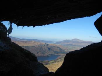
QOTW(80) After interest in the stone circles, what other ancient monument is disguised in this anagram? DUMBMOODGIE
Hardknott%20Fort.JPG)
This view shows Scafell from within the walls of the fort
John and Pat Baker gave this very concise description which includes a little more on the historic monument:
Hartknott Roman Fort (called MEDIOBOGDUM by the Romans) was built between 120 and 138AD. It`s the dramatic site at the peak of the famous pass of the same name. Because of its location the Romans were able to control the road, called the 10th. iter, which ran from Ravenglass (Glannaventa) on the west coast to Ambleside (Galava) on the eastern side of the mountains. Built during the reign of the Emperor Hadrian, the fort covers three acres. 500 infantrymen were stationed here.
Winner(s):
Number 79
Who can tell me the name of this remote Lakeland feature with it's outstanding view?
Winner(s):
Number 78
Liz Lemal has sent this photo to test everyone this week.
This shelter is by a popular track and is according to AW 'just big enough for one person or a honeymoon couple'. Where is the shelter A grid reference and description would be an ideal answer.
.JPG)
The shelter on the Walna Scar Road just east of the summit of the pass [Dow Crag 4] Grid reference SD 260 964
Winner(s):
Number 77
What's the six figure grid reference for Wath Bridge and what is unusual about it's location?
-wath%20bridge.JPG)
The Wath Bridge I was asking for (or was) found at NY 311 172 now 54 feet below the present surface level of Thirlmere. The bridge crossed a narrow reach of the lake (formally Leathes' Water) linking Armboth to Thirlspot. The bridge is pictured in this view from before 1858 (bottom right). The original lake is featured in An Atlas of The English Lakes by John Wilson Parker. Cicerone £16.95 ISBN 1-85284-355-1. Click below to go to the Cicerone Press online:
![]()
No winners this week!
Number 76
Which animal (not a bird) has been found at the summit of Ben Nevis? They have been seen running over the snow in winter but how they find sufficient insects on which to live is a mystery. Hover your mouse over the grey button for the answer:
Click below for links to web site about this amazing little creature
http://www.parish-wildlife.org.uk/Projects/Mammals/Shrews/pygmyshrew.htm
http://www.abdn.ac.uk/mammal/pshrew.htm
Why not play the shrew game - can you stay alive? You will need shockwave to play.
http://www.spinysoft.co.uk/simshrew.shtml
Winner(s):
Number 75
Where in the Lake District is the 'Kail Pot'? Click the below links for photographs.
Thanks to Pam Long for both answers displayed here.
http://web.ukonline.co.uk/mountains/30612.htm
http://www.howtownoac.co.uk/activity/kailpot.html
Winner(s):
Number 74
Where in 1730, were 17 loving couples united in holy matrimony by the local parish minister?
![]()
Winner(s):
Number 73
To continue the trend of the previous QOTW what did the word 'Leathes' previously lend its name to? Hover your mouse over the red sphere for the answer:
![]()
Winner(s):
John and Pat Baker provided the following information in their concise answer.
Number 72
What is the more common name to an island once labelled as Curwin's Island? We need the island's name and location.
Curwin's or Curwen's Island is the earlier name for Belle Isle, Windermere. It was named after the Curwens, descendants in direct line from Ivo de Taillebois, who came over with the William the Conqueror. This Island is private property; but all the other Islands may be explored at will. Belle Island is rather more than a mile in circumference; it possesses some pretty walks, shaded by fine old trees, and was the scene of severe conflicts during the Civil War. Smaller islands, on which lily of the valley luxuriates, cluster near Belle Island.
Thanks to John & Pat Baker for this extra information.
Winner(s):
Number 71
Can you identify the peak on this 3-D model of part of the Lake District?
.jpg)
Winner(s):
Number 70
The name of a very famous Lakeland public house has been removed from the pub sign. Can you recall the name that greets happy travellers in this remote but sometimes busy spot?
.jpg)
-answer-three%20shires%20inn-view.jpg)
The Three Shires in at Little Langdale
The photo above right was taken by Tony Richards and added to his site the night this question was set. How come there weren't 172 winners?
Winner(s):
Number 69
Name the fell. Cane you recognise the profile of a famous Lakeland peak in this photograph?
.jpg)
Of course it was Pillar. I think removing any evidence of Ennerdale Water made it hard.
Winner(s):
Number 68
Which famous novel starts, "Roger, aged seven, and no longer the youngest of the family, ran in wide zigzags, to and fro, across the steep field...........".
The answer was of course, Swallows and Amazons by Arthur Ransome
Winner(s):
Number 67
Where is this gill found on a northern fellside? There's a clue in the high street!
It is found in Skaftafell National Park, Iceland on the flanks of Skaftafell.
.jpg)
Winner(s):
Number 66
What is the missing word on this sign on the approach to Ben Ledi? I guess Cameron McNeish is a friend of these signs! Float your mouse over the photograph to reveal the answer.
.jpg)
Winner(s):
Number 65
Can you name this mountain featured in the photograph?
.jpg)
Winner(s):
Number 64
 Can
you name the full list of book titles which Alfred Wainwright had published
before his death in 1991. In future days several pages will be drawn up
focusing on the man who brought many of us onto the fells.
Can
you name the full list of book titles which Alfred Wainwright had published
before his death in 1991. In future days several pages will be drawn up
focusing on the man who brought many of us onto the fells.
The answer to this question is now posted on the OFC pages devoted to AW. If you have any contributions to these pages please feel free to send them in. Click here to go to the list of books:
Winner(s):
Number 63
Lakeland Location. Where is this and who was the local patron mentioned?
One of the prettiest villages in the Lake District. The village has a shape similar to that of a rugby ball with seventeenth-century houses curving around the edge. The main road through the village is flanked by wide greens, which are a riot of colour at this time of year. There are two pubs in the village, but the village school closed down and children now have to go to a nearby town for their schooling. A nearby castle was constructed under the guidance of Sir Robert Smirke, an eminent architect, dates back to 1810. The owner of the aforementioned castle was the patron of William Wordsworth and a popular local figure.
Photo by Les Strong
Winner(s):
![]() Number
62
Number
62
Lakeland Location. Where is this?
This is an apt name for this working sheep farm. Down in the valley, surrounded by good pasture, it also formerly served as a place of rest and refreshment for the traveller. Nearby, the Roman road from the fort at Galava, begins the ascent of Wrynose Pass, then visits the Duddon and Eskdale valleys before finally reaching the coast at the port of Ravensglass.
Later Norsemen built a 'thingmound' here, a terraced hillock where settlers met to iron out disputes and possibly make decisions concerning the government of the Langdale valleys. It is not known how long there has been a building on this site, but it was documented as a grand house in 1670 and there are indications that the north wing is of sixteenth-century construction. There are tales of smuggling both in and out of the valleys and the site, a good distance away from habitation, was well placed for secret meetings. Smugglers may no longer find a welcome but accommodation is still provided.
Winner(s):
Number 61
Andrew Leaney asks if anyone can identify the following inscription and its location:-
where_is_this_memorial%20(2).jpg)
The plaque can be found in Mickleden, Great Langdale, roughly below Pike O Stickle. Its right next to the path from the bottom of Stake Pass to the ODG. I thought someone would remember passing it on this 'main highway'.
NO WINNERS