![]()
![]() Walk
of the Month - by Richard Abbot
Walk
of the Month - by Richard Abbot
A Walk through Middle Earth

Could the Ribble Valley be the inspiration for J.R.R. Tolkien's Middle Earth?
Hurst Green - In the footsteps of the Fellowship
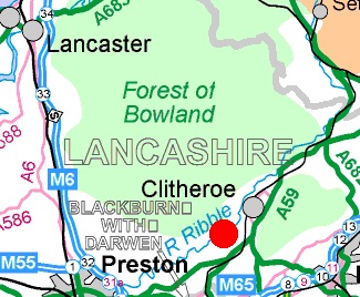
The red marker shows the location of Hurst Green, near Clitheroe
Information
Maps: OS 1:50000 Blackburn, Burnley & surrounding area Landranger 103.
Getting there: Hurst Green is easily accessible along the B6243 from either Clitheroe or Longridge. The surrounding area offers excellent accommodation and other good walking in the nearby Trough of Bowland and Forest of Pendle.
Grading: Easy
![]() Time
Take: 2 hours
Time
Take: 2 hours
![]() Ascent:
100 metres
Ascent:
100 metres
![]() Distance:
6 km
Distance:
6 km
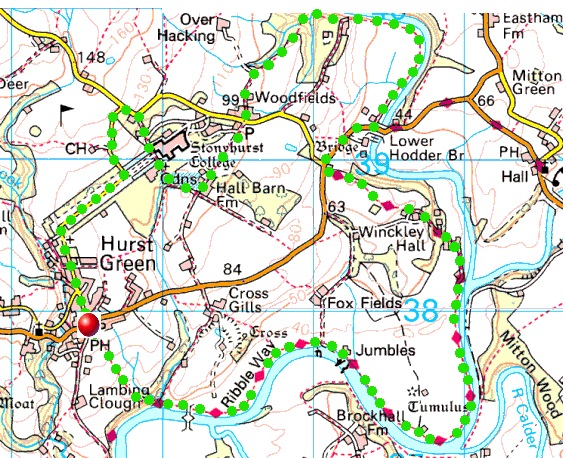
Walk to be taken counter-clockwise starting and finishing in the village of Hurst Green
Start:
![]()
Route
taken:
![]()
![]()
|
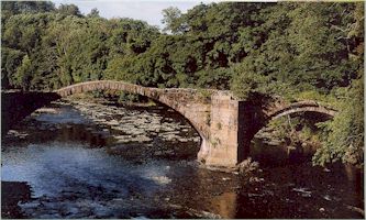
Devil's Bridge, over the River Hodder, is thought to be the inspiration for Brandywine Bridge
|
|
To try and decide, a walk through Middle Earth was attempted, comparing the map of Middle Earth which has Hobbiton, the River Shirebourne and the River Brandywine and the ferry that takes you across to the Old Forest with the Ribble Valley Map showing Hurst Green and the rivers Ribble and Hodder; including the ferry that hadn't run for years. It would be nice to believe that maybe the landscape of Tolkien's The Lord of the Rings trilogy, the first instalment the The Fellowship of the Ring which is now released as a film; is copied from this corner of the Ribble Valley, in the misty, green Lancashire countryside near Clitheroe. Or that you can trace the route Frodo Baggins and chums take as they head across the Shire, through the Old Forest on towards the Crack of Doom, carrying with them the Ruling Ring of Power, which they must destroy.
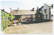
The walk starts from the Shireburn Arms, and even this pub has a place in The Lord of the Rings. J.R.R. Tolkien, who was partial to his beer, was a regular visitor in the 1940's. He came to visit his eldest son, John, who was studying for the priesthood at the Jesuit seminary at St. Mary's Hall, now the prep school for Stonyhurst College. The impressive approach to grand, grey, towered and turreted Stonyhurst begins at the edge of Hobbiton, or rather Hurst Green, and it would feature later in the walk. Tolkien loved woods and walking, and he roamed all over the Ribble Valley. The places he visited and their names, often found their way into The Lord of the Rings. Leaving the Shireburn Arms and setting off in his footsteps, cross the field beside the pub, heading for the wide, rippling, foam-flecked and fast flowing Ribble. Scattered across the landscape there are green mounds too big to be man-made burial mounds but too small to be hills. Pass an old iron bath, dug into the hillside beneath a spring, the water from which fills it before trickling over the top and on down to the river. This was one of Tolkien's favourite walks. He would amble along here to the spot where a passenger ferry used to cross the Ribble, at the point where it is joined by two other rivers - the Calder and the Hodder. The ferry hasn't run since the 1950's, but it was here in Tolkien's day and he used it as the inspiration for the Buckleby Ferry, in which Frodo and friends take to leave the Shire and enter the Old Forest. The boathouse was dismantled and taken to the museum in Clitheroe. Across the bank is the imposing
Elizabethan pile of Hacking Hall, which is Brandy Hall in the book, and
Mitton Wood, the dark, conifer groves behind it, which became the start of
the Old Forest. Head north following the River Hodder (the Brandywine River
in the book) and pass an earthen mound which, in the book, becomes the long
barrow which swallows up Frodo. At Winkley Hall Farm the path turns inland,
winds through the farmyard and crests a rise. Before you is Stonyhurst
College in all its stately splendour. Before heading to it, take a quick
detour to Tolkien's Brandywine Bridge, which takes his Great East Road (the
B6243) across the river. It's really Lower Hodder Bridge and, beside it, is
the ominously named Devil's Bridge, the three arches still standing. Its
sides removed, it said by Cromwell so that he could get his carts over as he
went about subjugating a local Catholic stronghold. (At Stonyhurst, Cromwell
rested - sleeping, the story has it, in full armour on a table. The table
is now on display).
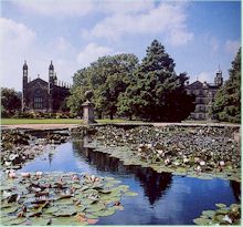
Stonyhurst marks almost the end of the walk. When Tolkien visited, he stayed at a grey-stone Edwardian guest house, 'New Lodge', which is now home to the deputy head of St. Mary's and which Tolkien sketched on one of his last visits. This building is passed in the lane on the way down to the college. 'New Lodge' entered Tolkien's fiction as Tom Bombadil's home, where Frodo spends a brief respite from his gruelling journey. The college itself is breathtaking with two chapels almost as big as cathedrals, grand staircases and corridors wide enough to drive down. Originally an Elizabethan mansion built by Sir Richard Shireburn (that name again), it was given to the Jesuit order of St. Omer in France in 1794 and they moved their school here. Among the treasures that Stonyhurst College owns are a 7th century Gospel of St. John, said to have been used by St. Cuthbert of Lindisfarne, a gold cloak worn by Henry VIII, and a chasuble belonging to Catherine of Aragon. They also have the Book of Hours that Mary Queen of Scots carried to her execution. No fewer than three former pupils have achieved sainthood And of course, there is the Tolkien connection, which continued when his second son, Michael, taught at the school in the late 1960's and early 1970's. Tolkien, who died in 1973, persuaded him to plant a copse in the garden of the school house he occupied, 'Woodfields', on the road to Hodder Bridge. The driveway that takes you back to the village stretches dead straight for half-mile, flanked by two long oblongs of black water and rugby pitches, finally rounding a bend brings you back to Hobbiton. Or Hurst Green. Is it possible that the map of Middle Earth works? Text taken from an article in the Mail on Sunday 25th November 2001 by Richard Abbott. Related Links: http://www.jrrtolkien.org.uk/tolkien_in_lancashire.htm http://www.travellady.com/Issues/Issue70/70Q-lord.htm http://www.jrrtolkien.org.uk/stonyhurst_college.htm
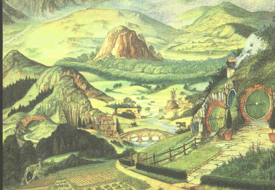
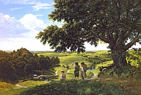
The Shire or the Ribble Valley? (Hobbiton, by Roger Garland) |
 A
dispute has broken out over the geographical inspiration for The Lord of
the Rings. Is Birmingham's Sarehole Mill in Moseley the true
inspiration for the Shire home of the Hobbits? This was Tolkien's childhood
playground. Or is it in the Ribble Valley, where Tolkien wrote most of the
The Lord of the Rings having visited Stonyhurst College. Could
Hobbiton actually be the nearby village of Hurst Green and the River
Shirebourne named after the Shireburn family who built the Stonyhurst
estate? Follow the map of Clitheroe's fields and, it is claimed, you can
trace Frodo Baggin's route across the Shire, through the Old Forest and on
towards the Crack of Doom. The Old Forest is then not Birmingham's Moseley
bog after all but the conifer groves of Clitheroe's Mitton Wood.
A
dispute has broken out over the geographical inspiration for The Lord of
the Rings. Is Birmingham's Sarehole Mill in Moseley the true
inspiration for the Shire home of the Hobbits? This was Tolkien's childhood
playground. Or is it in the Ribble Valley, where Tolkien wrote most of the
The Lord of the Rings having visited Stonyhurst College. Could
Hobbiton actually be the nearby village of Hurst Green and the River
Shirebourne named after the Shireburn family who built the Stonyhurst
estate? Follow the map of Clitheroe's fields and, it is claimed, you can
trace Frodo Baggin's route across the Shire, through the Old Forest and on
towards the Crack of Doom. The Old Forest is then not Birmingham's Moseley
bog after all but the conifer groves of Clitheroe's Mitton Wood.