The Auxilia of the Roman Army in North Wales
David Alexander
Introduction
Wales, today, a Principality, attached to England, but separated for its whole length by the Cambrian Mountains, did not exist as such during the Ist Century A.D when the Roman army occupied southern Britain. The area that was to become Wales was a part of Celtic Britain as a whole, the people being similar to those living in the modern areas of Yorkshire and Scotland.
There is some debate to the original extent of the Roman Conquest initially planned in A.D 43. Some hold with the plan being only to hold the southern area of Britain, this being the area most receptive to ‘romanization’ due to its already engaging with trade with Gaul from, or before Caesar’s expeditions in the 1st Century BC.
The frontier, which the Roman army had set at the Fosseway, adjoined modern South Wales and Gloucestershire. The Silures, the dominant tribe of this area had been raiding the new Roman province; three of the first governors had engaged in forays against these Celts, Suetonius Paulinus’s predecessor, Veranius, died in office after boasting all of Wales could have been his in two years. In A.D 58-61 Suetonius Paulinus made two campaigns into Wales. The first against the Silures of South Wales, and the second in North Wales against the Ordovices or the Deceangli, finally Anglesey is occupied, but the Boudican revolt, announced to Paulinus while he is still at Anglesey meant he couldn’t consolidate his gains. Until 74, Wales appeared to receive no further campaigns, when Frontinus, governor 74-78 finally defeated the Silures, and possibly the Ordovices.
The Ordovices, however, rebelled in 78 and Julius Agricola attacks North Wales with a series of lightning attacks, re-occupying Anglesey, which had apparently seen the army the year before, and the Celtic occupants considered themselves doubly conquered.
The conquest of North Wales used Wroxetter/Viriconium as a springboard, there had been no urban development at this point but Legio 14 Gemina Victrix had established a fort there about 58AD. Using the valleys as entrance points the Roman army penetrated modern Merionedd, and Caernarfonshire in a series of forays to reach Anglesey an area already subjugated by Frontinus the previous year. Here, across the Menai Strait, the important fort of Segontium was established.
The area of Chester/Deva contained a Legionary fortress and this was used to head the campaign into modern Denbighshire, Flintshire.
By 78 AD North Wales was under Roman control. The indigenous Celtic population had encountered Rome previously in the years 48 A.D and 61 A.D. These people in common to other northern Celts had more in common with Bronze age peoples than the southern Belgic tribes, put up fierce opposition. Tacitus records a Roman Cavalry unit being exterminated by the Ordovices in Merionedd, in the first year of Agricola’s governership.
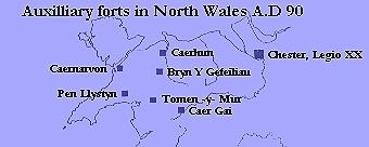
Southern Wales was secured by Legio 2 Augusta from Isca/Caerleon, while North Wales was held by Legio 2 Aduitrix, at this early stage at Chester; soon to be replaced by Legio 20 Valeria Victrix. The whole area was secured by auxiliary forts placed at the familiar one days march from each other. The North Wales area of which is dealt with here are the modern counties of Denbs, Flint, Gwynedd and Merionedd, these forts are fairly traceable with the exception of Denbs, Flint, which is incomplete possibly due to the encroachments of agriculture.
The area had at least one fort, which today cannot be traced, the Antonine Itinerary names ‘Varis’ or ‘Varae’ between Kanovium and Deva. The site may be modern St Asaph, located on the River Clwyd. Much Roman material has been found, and the town is situated on a junction of Roman roads from the Vale of Clwyd, and Chester, the road then heads for Caerhun, westerly.
There is a large Roman site at Prestayn, though no fort is yet proven. Excavations in 1985 revealed much evidence of industry and rediscovered a small bathhouse, which is consolidated and on display. The bathhouse had many stamped tiles of Legio 20 Valeria Victrix, but the site is not specifically military, and has no auxilia connotations.
Ruthin, situated south of St Asaph in the vale of Clwyd, has produced evidence of several early forts, in earth and timber, and possibly marching camps. From excavation by the late G.D.B Jones of Manchester University, in the early 1990’s, the recovery of a late 1st Century cremation urn confirms military occupation of the site. The site, under Ruthin High School needs more excavation to clarify the occupation, again which type of Roman soldier served here is unsure due to lack of diagnostic finds from the rescue excavation.
The site, is an important one, and problems are posed by its closeness to Varae.
The auxiliary forts are as follows, see map.
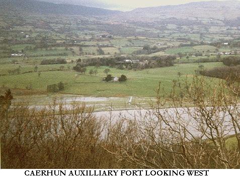
Caerhun/Kanovium
The fort at Caerhun, which the Romans called Kanovium is recorded from three contemporary sources, the Antonine Itinerary, The Ravenna Cosmology, and a milestone, recovered from the pass above the fort (see picture), which records Hadrian’s titles for A.D 121 and the distance to Kanovio, M P V111, 8 miles. The stone was found alongside the road to Segontium, which was one of four other milestones, spanning the period Hadrian to Constantine. The road is worth a visit, with much ‘agger’ preserved. This fine stone, which is a classic early milestone, can be viewed in the British Museum, and most books about Roman Britain.
Situated on the west bank of the River Conwy, this fort was established to control the river crossing, this route of pre Celtic origin was to become the main east/west Roman military road from Chester to Caernarvon.
The establishment of the station is attributed to either Frontinus or Agricola, in the year A.D78.
Initially planned as a 4-acre earth and timber fort, it was re-built in this format before the end of the 1st century A.D, finally being made permanent in stone under Antoninus Pius.
An interesting point is the stone used in the stone phase is red sandstone which is not found in this part of Wales, analysis of the stone proved the stone was sandstone from the Handbridge area of Chester about 50 kilometers to the east. Presumably, shipped in from Chester, this provides an insight into the building of these small forts. The stone was used to ‘clad’ the cut back turf rampart of the earlier fort.
The size of the fort, the amount of barracks, and finds of cavalry equipment point to the presence of a 500 mixed infantry/cavalry regiment, the cohors quinginaria equitata.
Occupation declined during the stone phase with coinage of the Antonines being very scarce.
The fort was destroyed by fire at the end of the 2nd Century, possibly at the time of Clodius Albinus’ attempt at wearing the purple. The Principia (unfinished) had some of its decorative stonework flung into the well in its courtyard.
There was major rebuilding in the 3rd century under Gallienus, the fort saw sporadic occupation through the Constantinian period, which may have been civilian, the last dated evidence being a coin Of Theodosius 1st, 379-95 AD.
No cohort is named from the site, which appears to have been radically stone robbed from the medieval period, the dedication slabs being first to be carried off, or smashed up.
Today the site is situated in the grounds of a stately home, a church occupies its north-east corner which is of mediaeval date, and contains much of the Cheshire sandstone, and the churchyard contains one hypocaust pillar from the bathhouse, now used to hold a sundial.
The square earthwork of the fort is traceable for its circuit; the north-east rampart is unlikely to be much reduced from its original height. Conspicuous remains between this rampart and the river is the bathhouse. North of this are the remains of a dock and it’s associated buildings.
Roads can be traced south and north, as can some of the forts large vicus.
Useful information
Significant finds for the site are displayed at the Llandudno Museum; these contain a copper ingot, an Italian amphora, Samian pottery, and many coins.
No public access but a public footpath crosses the site, the churchyard gives a good view of the bathhouse. Also its wall is constructed on top of the fort wall and follows the rounded corner, so a good idea of the original rampart height can be ascertained.
Permission to access the site can be obtained from Caerhun farm, opposite lane to fort.
The site is 4 miles south of Conwy on the B5106, 1 mile South of Caerhun village.
Caernarvon/Segontium
A fort established 78 A.D, of 5 ½ acres, presumably to hold a garrison of 1000 cavalry, a milliary cohort. Situated on a low hill overlooking modern Caernarvon with its famous castle, itself constructed in part with robbed stone from the Roman fort.
An important strategic site throughout the whole remaining period of Roman Britain, due to policing the western sea routes and the important island of Anglesey with its religious and mineral connections.
The fort went through the usual earth and timber and stone phases, the site visible today is the final 4th century re-build, with the usual blocked gateways.
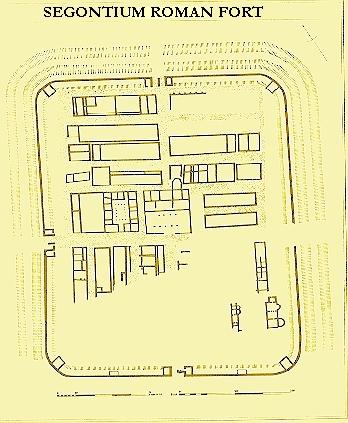
Visible remains are viewed as the best Roman fort in the UK outside Hadrians Wall, they contain much of the curtain wall, the south rampart being over 3 metres high with ‘putlog holes’ visible as well as a culvert arch. The north and west gates are well preserved complete with blocking walls, Principia with underground strong room and courtyard with its well. Other footings are preserved of barracks and Commander’s residence, and granary.
The fort is recorded in the early 3rd century as being decrepit. The famous aqueduct inscription records that the 1st Cohort of Sunici, a 500 infantry regiment, cohors quingenary peditata rebuilt the forts water supply and headquarters building for the Emperors Severus, Antoninus, and Geta. Geta’s name was erased after his murder by Antoninus/ Caracalla.
The fort was one of the longest garrisoned sites in Britain, occupation lasting until the very last years of the 4th century, this in common with Caerhun was probably due to the copper mines of Anglesey and The Great Orme.
Interesting facts
The name of the site, Segontium, is named after the local river, the Seiont.
The site claims personal links with both Constantine and Magnus Maximus, both unsubstantiated. Maximus was held to have emptied the garrison for the last time, though recently later coins have been found beyond 390.
Large vicus, a Mithraeum, sadly now under a housing estate, several bathhouses (inside the fort) a large stonewalled store compound to the west of site down the hill. This site with walls 4 ½ metres high was long held to be a fort, but now ‘Hen Waliau’, which means ‘old walls’ is believed to be a 4th century naval supply depot.
Significant finds are on display in the excellent site museum, these contain a Gladius, copy, (infantry short sword) a gold crossbow brooch, a gold Gnostic talisman, much pottery, coinage and items of everyday life, recovered in the 1920’s excavations by Mortimer Wheeler.
The site can be found on the A4085 to Beddgelert, 1 mile from Caernarfon town centre.
National Trust, small admission charge.
Bryn Y Gefeiliaiu
4-acre site, with 4-acre annex attached to west rampart, established A.D 90; believed to be the Romans consolidating their hold on Wales following the withdrawal from Caledonia.
Site believed (due to large amounts of Scoria found in excavations) to be mostly concerned with lead mining. Lead mines exist nearby, but cannot be accurately dated to this period. The site is situated, uncharacteristically, on a flood plain of the River Llugwy, overlooked on two sides. Remains today, in this romantic setting dominated by Moel Siabod, consist of the ploughed out rampart and ditches, the annex, however contains what may have been a mansio and bathhouse and consist of three ranges of rooms around a central courtyard. These remains are stone and stand many courses high, almost over a metre in places; they are a surprising site to see in Snowdonia, where Roman remains are as a rule robbed to footings.
No names of garrisons have come down to us, or the Roman name for the castrum. The size of the site suggests a mixed Cohort of 500, similar to its sister fort of Caerhun, 12 miles away on the north road, known today as ‘Sarn Helen’.
Occupation of a military nature appears to have ended by 180 A.D, though the Mansio appears to have been used into the 3rd century.
Interesting facts
The site has been called ‘the first litter spot of Snowdonia’ due to vast amounts of amphorae fragments remaining under most of the site, due to the mansio being used as a tavern. The finds of the 1920s excavation by J P Hall where not considerable, consisting mostly of pottery, a complete Italian amphorae being recovered from the mansio. These can be viewed at Bangor Museum of Welsh Antiquities.
The site is reached by a minor road east of Capel Curig near the ‘Ugly House’, on the A5. Situated on private farmland, permission to view site can be obtained from the farm of the same name to the south of site.
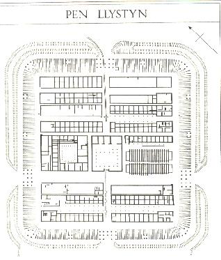
Tomen y Mur
The remarkable remains have been described as the most complete complex of Roman military remains in the Roman Empire. The reduced 2nd Century stone fort stands amidst a bathhouse, vicus, parade ground, tombs, aqueducts, roads, bridge abutment and even an amphitheatre. The amphitheatre is unique in Britain at an auxiliary fort, though not on the size of Legionary examples. It provides an interesting insight into the auxiliary castrum of the 1st and 2nd century. Also examples of practice camps at Dolddinas (south) and a Tilery (south at Pen y Stryd) prove auxilia were engaged in other duties than policing.
The early earth fort of AD 78, for 1000 cavalry, was replaced in Hadrianic times by the reduced remaining stone fort for 500 infantry. A Norman motte overlies its north gate.
The fort was given up circa 140, its remoteness protecting the remains seen today.
No excavations on site, some Centurial stones are displayed at Segontium site museum, part of a large amount found in Victorian times.
The site is private farmland; access is with permission from the farm at start of minor road, though some parts of the site are on Crown land, the amphitheatre and the lane up to the motte, this is accessible to the public.
No garrisons are known to us, or the name of fort. The fort lies on Sarn Helen south of Bryn y Gefeiliau, and can be reached under a railway bridge south of Trawsfynydd on the A470, then onto a minor road, for 2 miles.
Caer Gai
The 4 acre Fort, established 78 A.D, rebuilt in stone in Hadrianic times and given up A.D 140, is situated at the south- western end of Bala lake on the route from Chester to the Mawddach estuary. This fort has the distinction of providing us with an inscription that records the name of a soldier and his cohort serving here, though sadly not the name of the fort. This rare example of Roman ephigraphy of the late 1st C A.D is important because it is dealing with auxiliaries, whom normally didn’t leave written records in stone until the early 3rd Century. Found in the 1890’s, re-used covering a later cremation (Roman), it is a broken statue, mostly the base, of a sea monster, therefore thought to allude to one of the labours of Hercules. The inscription is as follows –
IVLIVS GAVERONIS F(filius) FE(cit) MIL(es) C(o)HO(rtis) 1 NER(viorum)
‘Julius, son of Gavero, a soldier in the first cohort of Nervii, set this up.
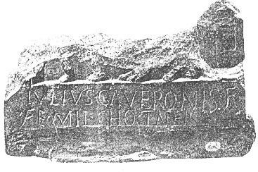
The burial this stone covered was of Hadrianic date, so presumably the Nervii had moved out and the new cohort dismantled standing monuments.
The condition in which the stone had been discovered (re-used) gives an important insight into Auxilia troop movements in the late 1st C AD. The Nervii had presumably been the forts first garrison, during 78, and under the control of Legio 2 Adiutrix, whose base was at Deva/Chester. Legio 2 Audiutrix established Deva in 78, but by 86 they had been moved out of Britannia, Legio 20 Valeria Victrix moving into Deva. So if the Nervii left with Leg 2 Audiutrix they had only garrisoned Caer Gai for eight years. Presumably the 20th brought new cohors with them and it was this unit that dismantled the statue.
The fort today can be viewed as a platform in the farmland, with a modern farm and it’s outbuildings occupying a substantial area inside the fort. There are some good sections of rampart visible beneath modern farm walls.
The fort is situated north of the A594; permission to view should be obtained from the farm.
Caer Gybi
This is a 4th Century fortlet, situated at the town of Holyhead on the Isle of Anglesey. Its design is something of a mystery, in that it closely resembles forts of the ‘Saxon Shore’, it’s objective is similar in that the enemy is now approaching from the sea. During the 4th century the Irish had begun to raid North Wales, and a naval fort dealt with such incursions to this part of Wales. The structure is not unique; a similar larger fort was constructed at Cardiff, and also at Lancaster. Strangely no other such forts have been discovered between Cardiff and Lancaster, possibly in the case of Anglesey the Romans established the fortlet to defend the important copper mines at Parys mountain. Late occupation at Caerhun and Caernarvon is believed to be for the same reason.
This fortlet, in common with such structures in Gaul, was only three sided, the open side ran into Holyhead harbour, allowing the small, fast, warships used at this time to beach inside the fortlet. The Irish pirates, however, must have been a continual threat as their sites of occupation, known as ‘Irishmens huts’ have been located in Snowdonia of a 5th and 6th century date, presumably free to operate without threat once the Roman high command had finally been forced to abandon Britannia.
Today the site can be viewed as a structure 249 ft by 134 and 157 ft, with walls still standing to 4 to 5 metres high, and 2 metres thick, which was built of small stones in a ‘herring bone’ pattern. Also to be seen are traces of the rampart walk, 3 round towers and several gateways. The section which was constructed into the sea was demolished in Victorian times when the cliff the fortlet stands on was cut back.
The site owes its excellent state of preservation to the fact it is the site of St Gybi’s church, established in the 6th century. The church and churchyard occupies the interior of the fortlet. The structure today has much mediaeval and modern rebuilding evident in its walls and gateways. The site is in the protection of the National Trust, who allow free access to the site at any reasonable time.
Sign posted in Holyhead town centre.
The site saw some excavation by W.E Griffiths in 1954 but there where no dateable finds.
Pen Llystyn
This 4-½ acre fort, which stood 12 miles south of Caernarvon, was destroyed by gravel workings; the fort was entirely destroyed by 1964. Built in 78 A.D in timber, the fort was destroyed by fire 10 years later, the site then appeared to be reduced by the digging of a ditch across the Via Principalis. This work appears to be unfinished, and the fort was abandoned. Finally a 1-½ fortlet was built over the north end of the original fort.
The military interest in the site had ended by 150, though civilian occupation of the site continued for the whole Roman period.
The excavation of the site by Hogg, prior to its destruction, revealed the forts phases, though finds where not great, being very scarce indeed during its phase as a fortlet. These were placed in the National Museum of Wales. The excavations produced a remarkable plan of the fort, surprising in view of the erratic nature of the occupation.
Bibliography
Excavations on the site of the Roman fort of Kanovium at Caerhun, Caernarvonshire.
P.K Bailie Reynolds, Cardiff 1938.
The Roman Frontier in Wales, second, revised edition, M.G Jarrett, Cardiff 1969.
Caer Llugwy (Bryn y Gefieliau) excavation of the Roman fort between Capel Curig and Bettws-y-Coed. J.P Hall, Manchester 1923
A Companion to Roman Britain, Guy De La Bedoyere, Tempus 1999.
Segontium and the Roman occupation of Wales. R.E.M Wheeler, Y Cymmrodor 1923.
Snowdonia From The Air, Patterns in the Landscape. Peter Crew and Chris Musson.
Snowdonia National Park Authority 1996 – For Tomen y Mur.
Museums displaying Roman material
Bangor Museum of Welsh Antiquities
Displays the Gladius from Segontium, and many finds from local excavations and casual finds, such as milestones, ceramics, bronze goods and a stone coffin.
Also on display are finds from Bryn y Gefeiliau fort, including complete amphorae.
Grosvenor Museum, 27 Grosvenor St, Chester.
Important collection from Legionary fortress of Deva, also material from supply depot of Bovium/Holt from over the border in Wales.
Llandudno Museum, 17-19 Gloddaeth St, Llandudno.
Displays finds from the 1920’s excavation of Kanovium. These include a palisade stake, cavalry accoutrements, a complete Samian bowl and cup, a Celtic stone head and a game board.
Segontium site Museum. Beddgelert Rd, Caernarvon.
Displays the rich finds of R.E.M Wheelers 1920’s excavation, the aqueduct inscription, altars, a solid gold crossbow brooch, much leather goods such as shoes and tent fragments. Also a life-size reconstruction of an auxiliary infantry soldier, which was constructed by the pioneer Roman armourer, the late H.Russell Robinson, armourer of the Tower of London.