| Return to home page |
|
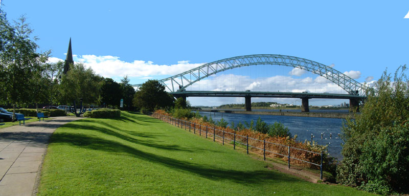
This is a view of the two bridges between Runcorn and Widnes which cross the River Mersey and the Manchester Ship Canal . The high level arch bridge was opened in 1961, and replaced an earlier Transporter bridge. The railway bridge, whose piers in the river can be seen behind the arch bridge, was built 100 years earlier, and carries the main railway line from Liverpool to London. |
|
|
The water which can be seen in the centre is the Manchester Ship Canal. Built just 100 years ago (my Grandfather worked on it when he was a youth during its construction), it now carries very little traffic, but until the arrival of container ships, vessels of up to 12,000 Tons used it to go to the docks at Manchester. Now it is too narrow and not deep enough to handle the larger ships. Its depth used to be some 9 m. (30 ft.) but it is no longer dredged,so the mud must slowly be filling it. The dock facilities at Manchester have all gone. Small vessels still use it occasionally, but the appearence of large numbers of ducks, geese and swans on the canal show how quiet the water has become, and indeed how much cleaner. I have seen cormorants diving in it for fish. Since the canal in its upper reaches takes water from a number of small rivers, it acts as a drainage for a large part of the Manchester area, and so cannot be filled in. After a period of high rainfall, not unusual in Manchester, the flow down the canal is very noticeable. Until 50 yrs. ago, the area to the left of the picture, between the road and the canal was a hive of activity for building barges, and other wooden sailing ships. (See Bibliography).
|
|
Beyond the sea wall which was built to separate the canal from the river, is the Mersey itself. At this point, and for some 4Kms. downstream, the canal was dug into what was the river bed and so the need for a wall to separate it from the remaining river. The River Mersey at Runcorn narrows from a broad estuary, and at each tide the speed of flow is quite remarkable. |
After a century of becoming the most polluted river in England, after an earlier reputation as one of its finest salmon rivers, a clean-up over the last few years is now showing good results. In 1999 salmon were reported jumping the weir at Warrington, some 10Kms upstream from Runcorn. It has always been one of my life's hopes that I would see people fishing in the Mersey again at Runcorn and Widnes, the town on the other side of the river, and this may yet happen. I frequently see herons on the sandbanks in the river when the tide is low, so obviously there is food for them there. In Nov. 2001 two salmon were caught in the Mersey, the first in living memory, at Warrington. One weighed in at 15lbs (6.8 Kg), and was said to be in very good condition. The fish were released back into the river
|
This view also has connections with Runcorn's early history. The pier of the railway bridge which is just behind the large trees in the centre of the picture, stands on the site of "Castle Rock". Most of this promentory into the Mersey was destroyed by the building of the railway bridge and the later canal. |
The Saxon Queen Aethelflaed built a fortification on Castle Rock in 915 A.D., to protect the northern frontier of her kingdom against the Vikings. "Widnes" is said to derive from a Viking name, "Runcorn" from a Saxon one. Where there was a fortification there would have been a church. The Parish Church of All Saints, seen on the left of the picture, was rebuilt 150yrs. ago on the site of an earlier square towered Medieval church. This could have been the site of the church which the Augustinian Canons of Runcorn Priory built in 1115 A.D. and where they were for 19 years before they moved to Norton, a distance of some 6 Kms., in 1134 A.D. A local historian friend of mine, Bert Starkey, who has written books on Runcorn, (See Bibliography). has pointed out that the Medieval centre of Runcorn, which was little more than a fishing village and not even mentioned in the Domesday survey (c.1086 A.D), was almost 800m. from the church, whereas churches would normally be a central part of a village. This could point to the church having been put there for other reasons. It could have been due to the Saxon fortification having a church there, and the Canons 'adopting' the site for their Priory Church, and rebuilding in stone. In the 19 years that they were at Runcorn a considerable amount of building would have taken place, and the church was always the first permanent structure to be erected. There is no archaeological evidence available,since all the ground around the church has been disturbed by centuries of buriels.
The Priory Church at Runcorn was dedicated to St. Bertholin, who was a Saxon Saint, although the England was then ruled by the Normans. This situation mirrors that at Chester, where a Saxon monastic site, dedicated to St. Werburgh, was also converted to a Benedictine Abbey, still dedicated to the same Saint. Today this is Chester Cathedral.
Norman Cheshire was ruled by the Earl of Chester from his castle there. Under the Earl were eight Barons, the most important of these being the Baron of Halton. He built a castle on the hill at Halton. The seventh Baron of Halton, Roger Lacy, was said to have been the most powerful of the Barons in the realm during his tenure of the Barony. Two other very famous Barons were John of Gaunt (14th. Baron) and his son Henry Bolingbroke (15th. and last Baron) who became King Henry IV. By that time the Barony was only a small part of the possessions of these men who were also Dukes of Lancaster.
The fact that Runcorn itself was not mentioned in the Domesday Survey of 1086, although the surrounding villages of Halton, Weston, Aston, Sutton and Stockham were, may have been a result of the "Harrying of the North" carried out by William the Conqueror to subdue parts of the North of England. Any destruction may have made Runcorn valueless at the time of the Survey, although it still appeared to have had a church. On the other hand the values of several of the local areas: Weston, Aston and Halton, appear to have increased between the time of Edward and William, inferring that there was little or no destruction in the area. Also, there were two priests listed in Domesday for Halton, so Runcorn could well have been integrated into Halton at that time, with "Runcorn" being a small local area of that name(?). Unfortunately there is no firm Archaeological evidence as to what was the size of Runcorn (Rumcofan) at that time.
A small digression. At this point on the river, there was a ferry across the Mersey, immortalised by the late Stanley Holloway in "Runcorn Ferry" and its famous line "Tuppence per person per trip" !. For a short time after the Canal was opened the ferry still operated. However, ferry passengers going from Runcorn to Widnes now had to take one boat across the canal, then climb up and over the sea wall between the canal and the river, then down the other side of the wall and into another ferry boat to go across the river itself! Anyone from Widnes had to take the reverse route to get to Runcorn, of course. Quite an ordeal. However a footpath was added to the railway bridge in the early 1900,s and this took over from the ferry.
On the Widnes side of the Mersey the slipway for the passengers to walk up can still be seen. The Inn where the travellers could rest and have a drink before getting on the ferryboat,(which was rowed across the river), can still be visited. It was called "Snig Pie House", but is now the "Mersey Hotel". At Runcorn nothing now remains as a reminder of the ferry.
The Canons of Runcorn Priory were given all the land in Runcorn, but relinquished this on moving to Norton. They were given a tenth of the profits from Runcorn Ferry, however. The reason for the move to Norton can only be guessed at. A strong possibility is that the Baron of Halton, whose father had founded Runcorn Priory, wanted to regain control of the strategic river crossing at Runcorn, which had been given to the Canons. After the move to Norton the Canons had more endowments than they had at Runcorn, so some form of bribery could be implied to get them to move.
|
On the Widnes side of the river, in the centre of the picture, there appears to be a small hill. This is a mound of chemical waste, a remnant of the old chemical industry in Widnes, an industry which has now almost disappeared. There were many such "hills" around Widnes and became known as the "Widnes Alps". All have now been landscaped, as has the one seen here, or flattened and used as recreational land. |