|
CHAPTER 1. GEOGRAPHY AND ORIGIN |
Cranham's unquestionable antiquity is because of its geography. The geography of any district is always its most durable feature; every generation works with, or against, the same geographical conditions. The physical features of a place dictate its prosperity, and how the generations survive. Cranham has been an attractive place for people to live for about a thousand years.
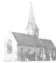
Cranham lies on the northern flood plane of the River Thames. As on any flood plain, the ground is higher as one walks further from the river. At Cranham, the 300 foot contour is touched at Coombe Lodge at the north (figure 2). Spot heights in the south of the parish include 84 feet at All Saints' parish church, and 72 feet at the junction of Pike Lane with the Ockendon Road. Wantz Corner is less than 50 feet above sea level, and this enhances the prominence of the church spire on the skyline, to its South; on certain spring mornings the fog lies thickly about this road junction, and yet is absent elsewhere in the parish. (A full map of the parish is available.)
As on most flood plains, Cranham is a fertile place. In 1886 (5), the geology was described as "loamy soil on gravel and clay". The rise in the north of the parish represents the start of the boulder clay, on top of the London clay. We have rich arable land today; here and there the land also supports woodland. Only recently has housing development supplanted agriculture as the principal reason for people to live here. Today, some two thirds of the parish is still under cultivation.
Subject to occasional summer droughts, Cranham is in the driest part of England. About 24 inches of rain falls each year. The weather at Cranham is generally without extremes, permits both summer and winter crops to be grown on its fertile surface, and does not generally require the indoor sheltering of livestock during the winter.
There is no documentary or physical evidence specific to how Cranham came to be defined as its own parish. We must assume that Cranham was involved in the general changes taking place in the County as a whole. Although some stone-age, archeological finds are scattered around Essex, the start of large-scale colonization of this part of England appears to be in the Iron Age, by a tribe known as the Trinovantes.
The Trinovantes probably arose as an off-shoot of the Belgae (their pottery has similarities). Their invention of a heavy plough enabled forest clearance and the colonization of S.E.England. The tribe lived in scattered, little clearings in the forest, and along the ancient trackways, and their houses were meagre, round, pole-huts, covered in turf and skins, which can be dated at least as early as 200 B.C.(7). They eventually seem to have developed a capital at Colchester before the Roman conquest, and developed the concept of Kingship and a coinage. One Trinovante King, Cassibellinus, helped repel the two invasions under Julius Caesar in 55 B.C. and 50 B.C.
In 43 A.D., the combined forces of Claudius, Plautius and Vespasian came to Brittania, and this time the Romans came to stay. Although Boudicca (often called "Boadaceia", whose statue is on Westminster Bridge, and who was a Queen at Colchester) drove them back in the late fifties, there was a permanent roman presence in Essex by 60 A.D. Several roads were built and garrisoned in Essex, and the old British capital became a major Roman city called Camulodunum. Today, the place is called Colchester, reflecting both its ancient, British origin ("Col") and its roman development ("Caestra" = "-chester").
  |
  |
|
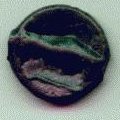
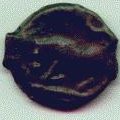
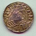
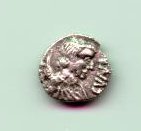
| Pre-Roman Iron Age coin from Colchester. Minted under the Chieftain known as Tasciovanus c. 10 BC - 10 AD; one side is an abstract design with a secret face in it, and the letters T-A-S-C round the edge, on the other side, quite off-centre is the bottom half of a horse with a few of the same letters. | Pre-Roman Iron Age coin from Colchester. Minted under the Chieftain Cunobeline (whom Shakespeare later called "Cymbaline") about AD 10-43, i.e. immediately before the Roman invasion. The similar horse has "C- V-(missing)N" underneath. The ear of corn has C-A-M-V either side for Camulodonum. The corn emphasizes the importance of Essex arable some 2000 years ago. | |
  |
  |
|
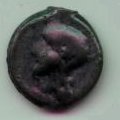
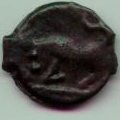
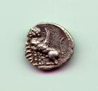
| Two bronze "potins" (cast coins) made by the Trinovantes c. 100-90 BC. The obverse is thought to be a crude copy of a head of the god Apollo, copied off an ancient greek coin. The reverse is a charging bull. These coins are known as "Thurrock types", for their supposed place of manufacture. | ||
  |
  |
|
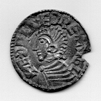
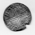
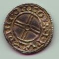
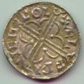
| Hammered silver penny from Colchester. This one is known as a "short cross type" (c.1029-1036), again with the king's head on the obverse. The mint mark is "COL" at the top of each reverse. The two moneyers were appointed by King Cnut, and are named on the coins "Aelfpine" and "Pvlfpine"; it appears that the letter P stands for the modern letter W. | Hammered silver penny from Colchester. This one (c.1017-1023 AD) has a quatrefoil design on one side, and the king's head on the other. The mint mark is "COL" at the top of each reverse. The two moneyers were appointed by King Cnut, and are named on the coins "Aelfpine" and "Pvlfpine"; it appears that the letter P stands for the modern letter W. | |
|
|
|
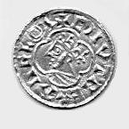
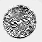
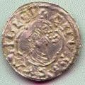
| Penny of Aethelred II ("The Unready") looking quite happy in his unreadiness. Minted between 997 and 1003 AD by Wulfwine of Colchester. The letters COL (with a dot at the centre of the letter O) may be seen near the top | A rare penny coin of Cnut minted at Maldon c.1017-1023 AD. The moneyer's name was probably Aelfwine, although the letter F has been omitted. Maldon is spelled Meldvne on this coin. Yet another late Anglo-saxon Essex mint was at Horndon on the Hill; its coins are extremely rare and no scanned image has yet been found available. | |
  |
||
|
||
It is said that Essex had seven major centres of Roman occupation. At Camulodonum (Colchester), Caesaromagus (Chelmsford), Heybridge (near Maldon), Great Chesterford and Othona (Bradwell-on-Sea), the evidence is quite clear. Smaller Roman towns included Durolitum, on the great road between Londinium and Caesaromagus. Durolitum was near present day Romford, although its exact location is a matter of current controversy (207, 208, 209).
Cranham lies about 5 miles, as the crow flies, from the great road (now the A12) running between Londinium and Camulodunum, the two greatest cities in Roman Brittania. There can be no doubt that many lesser Roman roads are yet to be discovered in Essex, and that many of these followed the routes of even more ancient tracks. The Roman administration probably led to many features of the Cranham landscape (chapter 2), and at least one road (chapter 15), although it is possible that the Romans adapted a system of agriculture in southern Essex that had been established even earlier.
After nearly four centuries, the Roman military withdrew. Whilst this was the end of Roman occupation politically, the Roman way of life doubtless persisted in Essex for many years after 410 A.D. (e.g. the villa at Rivenhall). Many retired soldiers would have been settled, becoming small, independent farmers.
Various petty kings and kingdoms came and went in the next few centuries (7). Many Essex "kings" were doubtless nothing more than violent leaders of relatively small groups of equally violent peasants. Eventually a series of Saxon invasions took place, introducing some stability in about the seventh century. There is good reason to believe that the two Domesday manors in Cranham are due to Saxon colonization of the Romanized agricultural system, and that the farming had not been interrupted during the dark ages (chapter 2 and chapter 3).
The county boundaries have hardly changed since the East Saxon kingdom was established. Saxon warriors were rewarded with land, units of which were known as a "mark", and organised into Hundreds; there were about 20 Hundreds in the County. A great warrior might receive an entire hundred, a lesser man a few marks. Some sort of legal system, based upon communal responsibility, and administered within the hundreds and marks (which became manors) was developed. Cranham lies in the Chafford Hundred. Other manors / parishes in Chafford Hundred are South Weald, North Ockendon, South Ockendon, Wennington, Thurrock, Brentwood, Childerditch, Upminster, Aveley, Grays Thurrock, Great Warley, Little Warley, Rainham, and Stifford.
Essex features relatively little in the Anglo-Saxon Chronicles before 850 A.D. A major Viking invasion took place in 869 A.D., and Danelaw (which included the whole of Essex) was agreed by Alfred, King of Wessex in 886 A.D. In late 937 A.D. the Saxon king Athelstan recovered Danelaw, only for it to revert under Ethelred the Unready in the 980s. Danegeld was paid in Essex on at least three occasions, in 994 by Ethelred, and to Olaff Tryggesson and Swein of Denmark, subsequently. Canute (a Dane) beat Edmund Ironside (a Saxon) at the Battle of "Assendune" (probably near Hadstock in North-west Essex) on October, 18 1015.
It is known that in about 614 A.D. King Siebert the Good of Wessex conquered the East Saxons. Siebert was a Christian and arranged for one Cidd (probably pronounced "Chadd") to be appointed Bishop in his newly conquered territory. Cidd apparently journeyed about in the forests, converting the peasants who lived in little nuclear villages, and set up a few, regional churches called "Minsters"; this approach was also used in Kent. The chapel at Bradwell was one such regional centre; Upminster and South- minster may have been others. Cidd was eventually buried at St.Mary's, Lastingham, Yorkshire, a church with a large crypt that probably reflects its monastic usage (234); he was made one of the earliest English saints. It is surprising that the most durable form of English organisation, the parish, originates in one of the least illuminated periods of history.
In Essex, many parish churches are close neighbours to ancient manor houses. The parish church often developed from a private, manorial chapel (or "oratory"). It is thought that during the Saxon era, these private churches gained the upper hand on the minsters for economic reasons. Cranham and Upminster are compared in these terms in Chapter 4. At present the parish lies in the south-west Essex Archdeaconry, held by the Suffragen Bishop of Barking, within the Diocese of Chelmsford (240).
Landscape involves more than geography. The landscape is the result of what human beings have been able to do with the geography (and geology) at their disposal.
Cranham is a long, tapering parish, roughly 3 1/2 miles north to south. The southern boundary stretches a mile and a half, whilst the northern edge is barely a thousand yards (figure 1). Cranham is one of a set of similarly shaped parishes, oriented more or less perpendicular to the course of the Thames, running from Upminster to Downham in a North-east to South-west row or "ladder".
The most beautiful map of Cranham is that for the tithe commutation, 25 1/2 inches to the mile, and drawn in 1840 (4). Every field is named, although some are now gone through amalgamation, or modern suburban building in the centre of the parish. Field names are an independent, specialised field of research. The list for Cranham reads:
It is easy to understand where some of these names came from. Some describe the shape of the field (Leg of Mutton Field). Other names describe the field's location (Wants Mead is at Wantz Corner; Wantz is an old Essex word for a crossroads). The location of Workhouse Field confirms the site of the Cranham workhouse.
Some of these field names tantalize us with clues about agriculture at Cranham in the middle ages. There is no evidence for open fields, and certainly no Enclosure Act. It is thought that Essex was heavily wooded, a thousand years ago, and that each man cleared his own land in a pioneering manner (these clearings are sometimes called "assarts"; 241). Grey (242) suggests that no common arable fields existed at all in Essex parishes, like Cranham, which lie relatively far away from the borders of Hertfordshire and Middlesex (243). Yet, unexpectedly, field names at Cranham tell us of headlands (an area used to turn the plough around at the end of a field, leading to ridge and furrow), and fallow; these would normally be expected to be associated with large, communal fields. Curiously, pears seem to have been of some importance in mediaeval Cranham (Pear Tree Field and Perry Field); frustratingly, no more information about the importance of this fruit has survived.
Frank's Wood is an ancient name, refers to the manor of Warley Franks, just across the boundary, and may be pre-Saxon. This wood has been a Cranham amenity for almost 50 years. Lately, part of it has been coppiced; whilst this technique is doubtless the correct way to manage a working wood, Frank's is an amenity, not a commercial enterprise; the damage done to the Hornbeams will take at least 30 years to recover, and the oaks probably a century.
Essex was in the Danelaw but not as firmly as, say, Lincolnshire. Only a few, coastal, Essex parishes have Danish names, and in Domesday Cranham, like the rest of Essex, is described by Saxon, not Danish units of measurement. It is not surprising that we find no Danish names amongst our fields.
Some of these field names may relate to events now long forgotten (Rainbow Field), people as yet undiscovered in our history (Gilman's Shaw). Some names may relate to annual fees that must be paid (perhaps Warfield). There have to be stories behind many of these names (especially Bedlam Field !), but, again, nothing has been found so far. Many of these field names also appear in other parishes.
The origins of the Cranham landscape are very ancient, as we shall see when we consider the origins of the Domesday manors of Wokydon Episcopi (Bishop's Ockendon) and Crauoho (Cranham).
There are two predominant types of village structure in Essex, namely that arranged around a green and that along a street Often street-villages also have scattered outlying farms and hamlets. The scattered farmhouses represent areas cleared from the forest at various periods over time. Communal fields are therefore rare in Essex (271).
Usually, the village arranged around a green is older, in our area at least early Saxon period (say 6th - 8th centuries). It is thought that the green might represent a central area where the cattle would be confined at night, somewhat like many present-day African villages, where the huts are arranged in a circle, and fences are drawn between them at night to contain the livestock. In the middle ages, the parish church, a pond or well, and the manorial smithy were on the edge, and the principal roads radiated away from the green (271). Upminster was a village arranged around a green, with all the typical features, but now, of course, obliterated by the St.Mary's Lane / Corbet's Tye Road / Station Road junction; amongst Essex greens, Upminster's was one of the smaller.
Cranham is a small street-village. This typically has the manor house and parish church next to each other on a promontory, with a few houses either side of a little street running away down the hill. In addition, it is entirely typical in Essex for the parish to include scattered farm houses, or perhaps smaller hamlets, scattered at some distance from the street-village.
In 1086, there were seventeen men in Cranham, whilst women and children were not counted. If we allow three wives for four men, and two to six children for each married couple, then we arrive at a Domesday population for Cranham of between 53 and 108 persons.
It took about 700 years for the population to double. The census of 1811 recorded 248 living souls. There was a gradual increase during the nineteenth century, but between 1891 and 1901 the population fell from 465 to 395.
Whether the fall in population at the turn of the century was due to epidemics of disease or to migration into the industrial areas of East London is uncertain. So far, only a unique case of migration from Cranham to London at this time has been found (255). One Thomas Bayley, aged 28, labourer, was resident at 49 Stanley Road, Stratford, had married a London girl two years his junior; they had two sons, both called Thomas, aged 3 months and 4 years, both born in Stratford. Other Bayley family members lived in Moor Lane. The population of the parish ceased to be counted separately in 1934 when the parish was included in the Hornchurch Urban District Council.
In 1992, it is difficult to estimate the population of the old parish because it has ceased to be a distinct local government entity. Using the 2 1/2 inch Ordnance Survey map, there appear to be about 3500 dwellings in the parish. At an average of 2.5 persons per dwelling, then about 8750 people live at Cranham.
The distribution of the population within the parish has also changed since mediaeval times (Figure 4). In the middle ages, Cranham Hall and the church, in the south of the parish, formed the most populous area; otherwise, there were scattered farmhouses up and down the parish. Whilst this ancient nucleus survives, it is now dwarfed by the central, one sixth of the parish that is dormitory suburb of London, surrounding the road junctions of Front Lane with Moor Lane, and with Avon Road.
It is likely that the population will age and then fall in the next decade. The price of housing has driven young people farther from London. It has been thirty years since the fastest residential development took place, largely purchased by those starting families a generation ago. The assumption above, that there is an average of 2.5 persons per dwelling was probably conservative 20 years ago, but may be an overestimate now.
In summary, in many ways, the origins of Cranham can be found to be quite typical when compared to the general history of Essex. The geography and geology, its most permanent feature, has dictated the way of life at Cranham for centuries. That way of life has created a landscape which still contains many ancient features. In Chapter 2 it will be shown for Cranham Hall and its farm that the agriculture has gone on without interruption since the Roman occupation; the same may also be true for those lands that comprised the other Domesday manor (Chapter 3). As a sparsely populated, rural parish, major changes to the way of life did not occur until the latter part of the last century.
The parish boundaries, however, probably result from a special process, observed amongst a row of parishes across the interior of the Essex (Chapter 4), but not in Essex as a whole. Again, unlike Essex as a whole, Cranham appears to be on the verge of radical changes in the composition of its population.