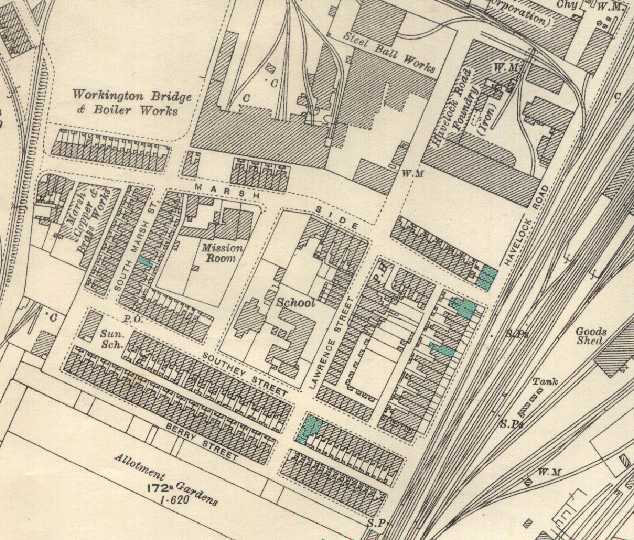
Look at the 26 inches-to-the-mile map of Marsh side below, which was published in 1926. If you click on the turquoisey-coloured sections, you will be taken to a picture of that section as it was in the late 1970's when demolition was in progress. Alternatively, you might just like to scroll down the page and click on any of the minatures to see a larger image.

Industry apart, the Marsh had changed very little from 1926 when the above map was published, until demolition in the early 1980's. The whole area is now unrecognisable, the main road to the new "out-of-town" shops, fast-food eateries and Chapel-Bank sweeping up what was Havelock Road and round what was Marsh Side. Stanley Street, which once was the main route through to Chapel Bank and the Quay, is now relegated to a quiet side-road where, I'm delighted to see, some new housing has been constructed!
The images above are, left-to-right:
The large brick building in the background was originally Havelock Road Iron Foundry, and is marked so on the OS map. It was taken over by the North Western Electricity Board - later N.O.R.W.E.B - and used as their maintenance depot. Part of the rear of the building was used as a store for Chapel Bank.
The first two images below are of the end of Havelock Road - literally! These three cottages were on the corner of Marsh Side and the wider section of Havelock Road. Not as grand as their neighbours further along, they were, nevertheless, just as tidy. Behind these houses was a piece of ground known by many as "The Basses". Quite why, I don't know. My Father remembers a roundabout and swings being erected on them at one time. I remember old tin garages and washing-lines when I used to play down there whilst visiting my Grandparents who lived on the Quay (Henry Street). The car, by the way, was mine; my second car - a Renault 12.
The house in the right-hand picture is - I think(?) - In Southey Street. I can't really remember, but some bearing can be taken from Chapel Bank works and the old slag bank visible in the background. You might know better, of course. Was it your house?
The future of the Marsh and Quay was decided at a Workington Council meeting in 1965, and in 1969, the Quay was compulsorarily purchased. Demolition started soon afterwards. The marsh, which was originally Priestgate Marsh and was filled up with ballast from ships docking in the harbour, consisted (just prior to clearance and demolition) of 216 houses, a shop, a post-office, a public house (The "Wheatsheaf"), a school (Lawrence Street) and a community centre.
Families started to leave the marsh in the 1970's, and by 1980, all that remained was what you see in these pictures.
Although it was mooted that the Marsh should be declared a "clearance area", the houses - mostly - were in decent condition and it is more than likely that these days much more thought would go into renovation, etc.
Any visitors to these pages who are interested in the Defence Infrastructure part of my site might be interested to learn that should Britain have succumbed to invasion in 1940, the Marsh had been especially selected by the Workington 5th Battalion Home Guard (Cumberland, affiliated to the Border regt.) as a "keep"; - A fortified area which, surrounded by sea, tank-impeding railway tracks, and accessible only by bridges - would have been defended to the bitter end....
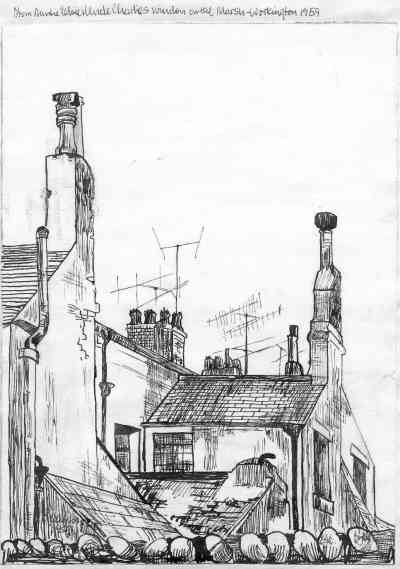
The drawing below and its associated explanation was very kindly sent to me by Edith G. Nilsberg, of Norway - but formerly of the Marsh. Edith can be found on the uk.local.cumbria newsgroup. In fact, Edith IS the uk.local.cumbria.newsgroup!
I quote.......
 "This drawing by Edith Grace Wright, was drawn in 1959. It shows the
first houses on the row at the bottom right hand side of Havelock Road on The Marsh,
the houses that were situated parallel with the Carlisle to Whitehaven railway line,
just on past Workington railway station.
The view drawn is from the upstairs window of the second or third house just around the corner on Southey Street, where Edith's auntie Elsie and uncle Charles (Wright) lived until their lovely home was shamefully demolished along with most of The Marsh and Quay."
Home | Contents | Defence Architecture | Links | E-Mail