PHOTOGRAPHS: David Parkin, Heysham
FURTHER INFORMATION: Jeff, contributor to uk.rec.subterranea NG
St Bees RADAR station - No. 87A ,'Chain Home Low' - was built at the Lighthouse in 1941, going off-air for the last time at 23:00 hours on 4th February 1944, after which RADAR coverage for the area was handled by the Hawcoats site near Barrow-in-Furness. Manned 24 hours a day by the RAF, St. Bees RADAR station was guarded by the Army who were billeted nearby. A good account of the military activity in St Bees during WWII is written elsewhere.

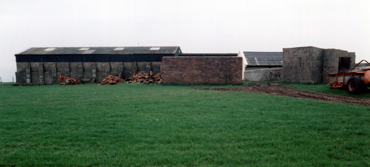
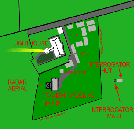
The station at St Bees consisted of a combined transmitter-receiver block (the remains of which are capped by a modern agricultural shed-roof in the above photograph), a 20' high gantry carrying the 1.5metre wavelength (200MHz) aerial array (which stood on the other side of the T/R building shown above), a stand-by set house, and various ancillary buildings. One hundred yards behind the main RADAR gantry - and perpendicular to the sea - stood an interrogator mast alongside the interrogator building. This hut housed a transmitter which was used to 'interrogate' a Mk3 IFF unit (IFF: 'Identification, Friend or Foe' - a device carried in aircraft to render them identifiable to radar systems). The Mk1 & Mk22 IFF systems responded to the actual radar pulse, but this became a problem when different frequencies were used, so the Mk3 IFF used a band of frequencies around 160 to 180 MHz - carried on a seperate transmitter, or 'interrogator' - causing the aircraft's IFF unit to respond with a pulse train that could contain simple data. Telephonic communication to plotters at Liverpool was established in April 1942.
 Older CHL sites had twin gantries and seperate transmitter and receiver buildings. St Bees was a 'West-Coast' RADAR station, and relied on dispersal of buildings for protection against the enemy. The more vulnerable 'East-Coast' RADAR stations utilised underground construction.
The graphic (left) is derived from Air Ministry drawing 60G/87A/2 created on 15th September 1942. It shows the site layout, and what is known to have been there. Note that on the photographs, the blast-wall protected building thought to be the Standby-Set house is actually nearer the T/R block than is shown on the graphic, being behind the brick blast-wall on the above photograph. It is not known how accurate the original Air-Ministry drawing was!
The road at the top of the graphic heads off down past Tarnflatt Hall to Sandwith. RAF radio activity in the area was not limited to St Bees RADAR. Just over three miles to the south-east stood a RAF radio beacon on Ivy Hill, near Bigrigg. These days the site is home to the UHF television transmitter relay.
The 'Chain Home Low' stations (CHL) were originally developed by Army scientists looking for a means of plotting shipping for coastal artillery. They were then turned to use for plotting low-flying aircraft - a function not successfully achieved by the larger 'Chain-Home' stations. The CHL stations had the advantage of being able to plot high-level aircraft as well. See Nick Catford's 'Subterranea Britannica' site for details about the Isle of Man CH station.
Home | Contents | Workington | Links | E-Mail