Click on the image of Nogbad to return to
the main menu.
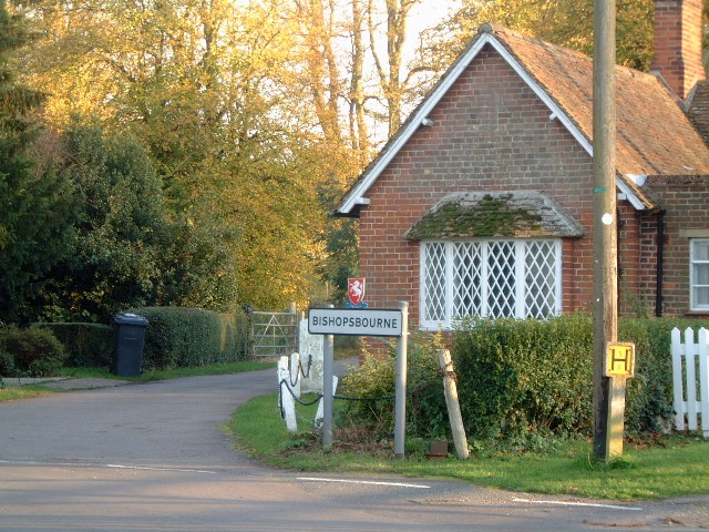
Bishopsbourne
nestles in the Nailbourne valley some four miles from Canterbury. The
village amenities are a lovely church, a forge, a postbox, a red
telephone box and The Mermaid - a public house.
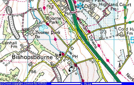
A note about the map: It's taken
from Multimap, linked from the word Bishopsbourne above, and on the
more detailed map they have missed the name off Station Hill and called
it Crow Camp Road in error. Crow Camp Road starts above the railway
bridge. The map is also vague about the location of the PH - look for
the phone symbol, follow the small black line showing that the phone
box is between two blocks, this is Park Lane. The Mermaid is on the
lower right-hand corner of the upper block, i.e. it is on the left of
The Street rather than across the river, behind the village hall as
indicated here.
I've had a
bit of a rethink on the Bishopsbourne pages and split them out into
separate sections. This means that the pages don't take as long to load
and as more images are added it'll be easier to manage.
To
everyone who has mailed me - I'm terribly sorry but my old PC suddenly
died and I lost the mails and email addresses. Please feel free to mail
me again, I hope to find a local historian who can do the wonderful
tales of life in Bishopsbourne justice.
General views around the village including
the church and Bourne Terrace:
I've got loads more photos of the village - if there
is any interest at all I'll upload them - mail me and let me know.
"And what is good, Phædrus, And what is not
good..., Need we ask anyone to tell us these things?" Pirsig
This page is made of recycled electrons - pass 'em
on, don't bin them.
It ain't what you do it's the way that you do it.
Weird but true - tonight (28/03/05) while sitting in
the pub the phone in the red telephone box outside started ringing. It
was a misty night and I've seen "An American Werewolf in London" so I
let it ring!
Click here to see
the full list of disclaimers and some information about an aquatic
legend.
This really isn't a rehearsal. Turn off your PC and
go outside. Meet someone new, say "Hello!", find out who they are and
add them to your list of friends, get their email address and mobile
number and keep in touch. Let us weirdos worry about keeping the
Internet going. Go on - you know it makes sense, do it while you still
can, get away, Run! Run! We'll keep you covered! It's too late for some
of us but you are still young!
Au is Dutch for Ouch!
If someone made a film of your life would you be the
star?
Structural stuff - it's a table with four uneven
columns that I've merged in places. This second bit is a nested table
so that I could use eccentric spacing without twisting the page out of
shape. I've used my standard css file, if you want to look it's at
../images/personal.css, for the colours and fonts and link decoration
and date.js for the date thingy. It all seems to behave in Slimbrowser,
Firefox, IE, Opera and Mozilla - let me know if your experience is
otherwise unless you are using a hand-rolled browser known only to
three people in which case keep it to yourself.
We put a man on the moon - is anything really
impossible?
Steve and Jackie are always happy to welcome new
custom at The Mermaid so please call in and have a beer - it's a fine
pub - I'm the young, tall, thin, tanned, athletic-looking guy sitting
at the bar with a book and a diet coke and the cigarettes are not mine,
I'm minding them for a friend. Update:I
really have stopped smoking.
Parking in Bishopsbourne can be troublesome on busy
weekends when the glitterati come out to play. It's best to park
somewhere between the pub and the village hall or on as far as the
church rather than down past The Mermaid and in front of Bourne
Cottages (that okay Jackie?)
As always - built using Macromedia Dreamweaver, NVU,
hand-coding, blood, sweat and beers.
If you are using IE with the latest
service pack and it screams like a screamy thing about Active X and
security it's the JavaScript used to fly a clock display at the top of
the page and a script I use to hide the email address from harvesters.
If you have the desire and the savvy grab the code for either or both
with my blessing but remember where you got them when you make your
first million! :-)