


For our project we chose to take various water samples along our route.
We chose this project as we thought it was both practical and would give us an
interesting set of results to look at.
The results our as follows:
| Test Number | Grid ref |
Pict number |
PH Level |
Acid/Alkalis/neutral |
Nitrate level | Nitrate level |
Nitrate level | Total Hardness | Total Hardness | Bacteria |
Other Info |
10mg/L |
1mg/L |
O.K/High |
ppm |
Soft-V.Hard |
Safe/Unsafe |
||||||
1 |
155,298 |
1 | 7 |
Neutral |
2 |
0.15 |
O.K |
250 |
V.Hard |
Unsafe |
Leads into and out of a duck pond. At our second campsite. |
2 |
102,301 | 2 | 6.5 |
Acid(slightly) |
0 |
0.22 |
O.K |
120 |
Hard |
Safe |
Linburn Beck. Crosses a B-road. |
3 |
067,299 | 3 | 6 |
Acid(slightly) |
0 |
0.22 |
O.K |
25 |
Soft |
Unsafe |
In Hamerstley forest clearing.Under some trees. |
4 |
038,268 | 4 | 5 |
Acid(slightly) |
0 |
0.22 |
O.K |
25 |
Soft |
Unsafe |
Thorny Cleugh. Comming out of Hamsterley forest |
5 |
991,246 | 5 | 7 |
Neutral |
0.5 |
0.22 |
O.K |
50 |
Hard |
Unsafe |
On the edge of the town at our second campsite. |
6 |
975,302 | 6 | 6 |
Acid(slightly) |
0 |
0.22 |
O.K |
85 |
Hard |
Unsafe |
Disused mine. |
7 |
981,317 | 7 | 5 |
Acid(slightly) |
0 |
0.07 |
O.K |
50 |
Hard |
V.Unsafe |
River tributery starting at 539m. |
8 |
051,347 | 8 | 5.5 |
Acid(slightly) |
0.5 |
0.07 |
O.K |
25 |
Soft |
Unsafe |
On the edge of Pikeston Fell national park. Heather country. |
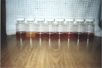
These are the collection bottles with the original collection water in them:
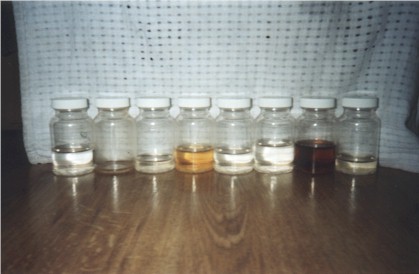
These are the containers with the bacteria results: